Satellite Imagery Shows China Building New Camp Near Site Of 15 June Clash In Galwan Valley
By at least one account, the Chinese have ‘stepped up their forces by at least 30 per cent since June 15’ along the Line of Actual Control.
After clashes between India and China in the Galwan Valley on 15 June, resulting in casualties on both sides, the military stand-off in eastern Ladakh has started to look more serious than any other in the last three decades.
Reports say that China has brought in additional forces to reinforce its positions.
By at least one account, the Chinese have “stepped up their forces by at least 30 per cent since June 15” along the Line of Actual Control.
China also appears to have opened a new flashpoint in the Daulat Beg Oldie (DBO) and Depsang sector, north of the Galwan Valley.
India too has moved troops in large numbers from peacetime locations to eastern Ladakh, including to Galwan, DBO and Deepsang Plains.
Latest reports say that the Indian Air Force’s heavy-lift aircraft have also moved T-90 tanks and Armoured Personnel Carrier to eastern Ladakh.
In the midst of reports about increased military buildup, a new satellite image of the Galwan Valley has added to the worry.
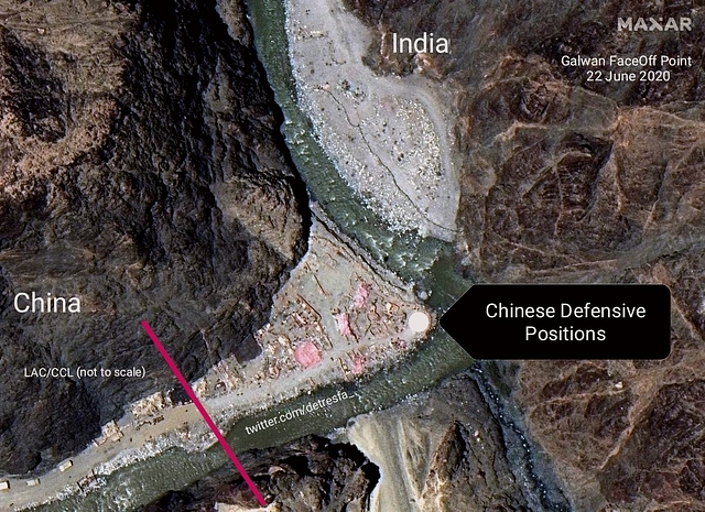
The Maxar Technologies image, posted on Twitter by Open Source Intelligence handle @detrasfa, shows that the Chinese are building a new camp close to Patrolling Point (PP14) 14 in Galwan, the site of the clashes on 15 June.
In military talks on 6 June, the two sides had agreed to disengage and decided that a Chinese tent close to PP14 will be removed by the PLA as part of efforts to defuse tensions. The Chinese removed the tent but came back a few days later to set up a new one on the Indian side of the LAC.
When Indian soldiers, led by Colonel Santosh Babu, confronted the Chinese side on this issue and asked them to dismantle the tent, they were attacked.
The Indian side had then dismantled and burnt down the Chinese tent.
Satellite images taken a day after the clashes near PP14 showed a large amount of debris at the spot where earlier satellite images showed a Chinese tent.
It is at this point, where a large amount of debris had been noticed following the 15 June clash, that the Chinese side appears to be building a new camp.
The new Chinese camp close to PP14 also appears to be larger and more sophisticated than the one seen before the clashes on 15 June.
Hectic activity is also visible in the part of the Galwan River Valley controlled by the Chinese. Heavy vehicles and earth moving equipment of the People’s Liberation Army are visible in satellite images, suggesting that the Chinese are building a road and new structures in the valley on their side.
Experts say that this development is worrisome because it comes at a time when the Indian and Chinese army commanders have agreed to a gradual and verifiable disengagement in eastern Ladakh.
Earlier, when the two sides agreed to disengage on 6 June, the Chinese side had not followed through on the understanding reached.
Security analysts say that the a short military conflict is not out of question if China refuses to leave the areas it has occupied, especially the area between Finger 4 and 8 on the northern bank of the Pangong Lake.
Local clashes, such as the one seen in the Galwan River Valley, can’t be ruled out either, experts say.