Infrastructure
Aerial Survey To Prepare DPR For East Coast Dedicated Freight Corridor
Arun Kumar Das
Apr 10, 2022, 12:39 PM | Updated 12:44 PM IST
Save & read from anywhere!
Bookmark stories for easy access on any device or the Swarajya app.
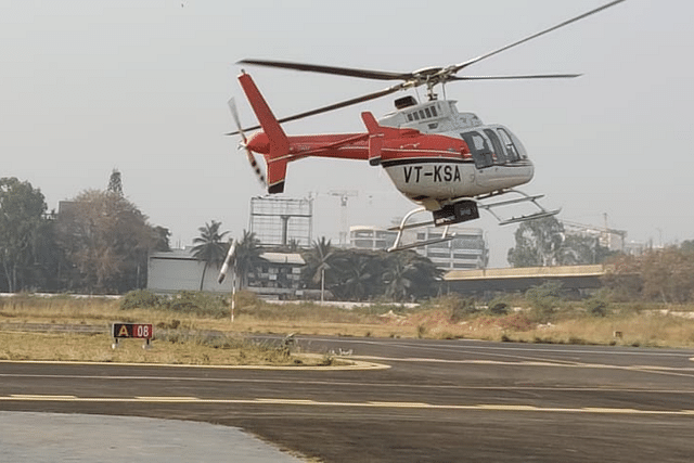
Dedicated Freight Corridor Corporation will be adopting the light detection and ranging survey (LiDAR) technique using laser-enabled equipment mounted on a helicopter to conduct the ground survey for the preparation of the detailed project report (DPR) for the proposed 1,115 km East Coast Dedicated Freight Corridor.
The corridor originates in Kharagpur in West Bengal, traverses Odisha, and terminates in Vijayawada (Tenali) in Andhra Pradesh. It will connect cities/towns like Baleshwar, Bhadrak, Khordha, Bhubaneswar, Rajahmundry, Visakhapatnam, Nellore, and Vijayawada.
During the aerial LiDAR survey, 300 metres of area around the proposed alignment will be captured for the survey purpose. After the collection of data, three dimensional (3D) topographical map of the proposed corridor’s alignment on a scale of 1:2500 will be available for the design of the vertical and horizontal alignment, structures, location of the stations and depots, land requirement for the corridor, identification of project affected plots/structures, right of way, and so on.
Alignment or ground survey is a crucial activity for any linear infrastructure project as the survey provides accurate details of areas around the alignment. The LiDAR survey provides all the ground details and data in two to three months against the 10-12 months if it had been done through traditional survey methods.
Keeping in mind the magnitude of the project and adhering to the timelines to submit the DPR of DFC corridor, reference points on the ground have already been marked and data collection through equipment mounted on a helicopter will commence from the start of the upcoming week (depending on the weather conditions) in a phased manner.
The requisite permissions from the Directorate General of Civil Aviation (DGCA) and Ministry of Defence for flying the helicopter have been received and the inspection of the aircraft and equipment are underway.
Aarvee Associates (Consultant) has been entrusted with preparing the DPRs for three DFC corridors, and the LiDAR survey for other two corridors shall commence shortly.
Save & read from anywhere!
Bookmark stories for easy access on any device or the Swarajya app.
Arun Kumar Das is a senior journalist covering railways. He can be contacted at akdas2005@gmail.com.
Support Swarajya's 50 Ground Reports Project & Sponsor A Story
Every general election Swarajya does a 50 ground reports project.
Aimed only at serious readers and those who appreciate the nuances of political undercurrents, the project provides a sense of India's electoral landscape. As you know, these reports are produced after considerable investment of travel, time and effort on the ground.
This time too we've kicked off the project in style and have covered over 30 constituencies already. If you're someone who appreciates such work and have enjoyed our coverage please consider sponsoring a ground report for just Rs 2999 to Rs 19,999 - it goes a long way in helping us produce more quality reportage.
You can also back this project by becoming a subscriber for as little as Rs 999 - so do click on this links and choose a plan that suits you and back us.
Click below to contribute.