Infrastructure
Satellite Imagery Shows How Joshimath Turned Into A ‘Sinking Town’
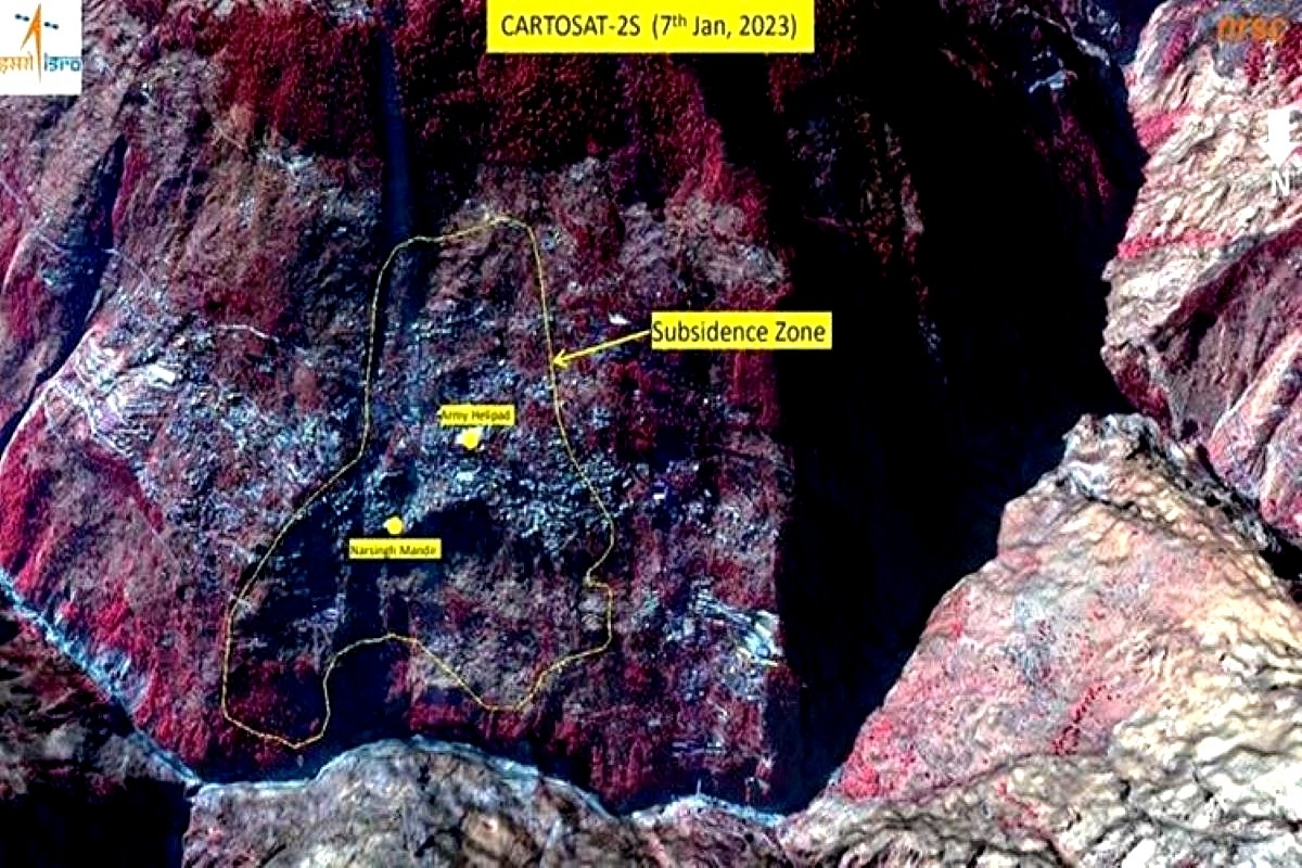
Joshimath land crisis: Satellite image
The report based on geological studies for Joshimath land crisis suggests that the rate of sinking has rapidly escalated over the past weeks.
The scientists and experts have been continuously engaged in studying the land subsidence in the town. Many teams are studying the cracks that have developed in the houses and the roads due the sinking of ground.
The town was declared a land subsidence-hit area after huge cracks developed in houses and other structures, roads and ground.
According to the report, between 27 December 2022 and 8 January 2023, the intensity of sinking has increased. This is the time where huge cracks emerged in numerous buildings and structures in the town.
During this period of two weeks, the ground has sunk by 5.4cm.
The NRSC shared satellite images taken from the Cartosat-2S satellite to describe the sinking of the land.
The image depicts the increase of subsidence to area including the Army Helipad and Narsingh Mandir.
“A subsidence zone resembling a generic landslide-shaped was identified, tapered at the top and fanning out at base,” the NRSC report informed.
These findings are based on the images processed through Sentinel-1 Satellite, with Synthetic Aperture Radar imagery which identify the possible location and extent of land subsidence in different time intervals.
The subsidence zone identified through the imagery was overlapped with the recent satellite images acquired by NRSC between 7 and 10 January 2023.
To avoid a disaster, the state government has begun rescue actions to evacuate people from risk prone regions. The people will be rehabilitated to safer locations.
For rehabilitation purposes, the government authorities have requested the Geological Survey of India to examine the suitability of Koti Farm, Herb Institute and the horticulture department's land in Joshimath and in Pipalkoti's Semaldala area.
Earlier, the scientist from the IIRS Dehradun presented satellite images which shows that the town had been sinking since the last 18 months.
The images show occurrence of land subsidence between July 2020 and March 2022. It states that the town had been sinking at a rate of 6 – 6.5 cm per year. The scientists had been tracking this through satellite images, and are now working to prepare a detailed report on the same.
Introducing ElectionsHQ + 50 Ground Reports Project
The 2024 elections might seem easy to guess, but there are some important questions that shouldn't be missed.
Do freebies still sway voters? Do people prioritise infrastructure when voting? How will Punjab vote?
The answers to these questions provide great insights into where we, as a country, are headed in the years to come.
Swarajya is starting a project with an aim to do 50 solid ground stories and a smart commentary service on WhatsApp, a one-of-a-kind. We'd love your support during this election season.
Click below to contribute.
Latest