Insta
Survey Of India To Use Drones For Mapping Maharastra Villages, Signs MoU With Department Of Revenue And Land Records
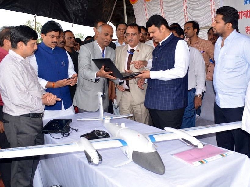
Maharastra CM Devendra Fadnavis launches the project. (via Twitter)
In a development that can have crucial learning outcomes for land mapping in the future, Survey of India - the national mapping agency of the country is set to utilise drones for covering 40,000 village ‘gaothan’ (rural) areas in Maharastra.
Survey of India, which works under the Ministry of Science & Technology, has signed an MoU with Department of Revenue and Land Records, Government of Maharashtra to undertake the large scale mapping exercise.
These village ‘gaothan’ areas have not been surveyed earlier and will be mapped at 1:500 scale covering all land parcels in the village for preparing accurate revenue maps and Geographic Information System (GIS) database. Drone survey will be pivotal to fix locations of village boundaries, canals, canal limits and roads in these villages.
Maharastra Chief Minister (CM) Devendra Fadnavis inaugurated the Drone based Mapping Project being carried out at Nimgaon Korhale in Ahmednagar district.
Professional grade drones will be used for the land survey by the agency. A presentation regarding the same had been made earlier which was attended by thousands of Sarpanch, Upsarpanch and farmers across the country and the Maharashtra state.
Introducing ElectionsHQ + 50 Ground Reports Project
The 2024 elections might seem easy to guess, but there are some important questions that shouldn't be missed.
Do freebies still sway voters? Do people prioritise infrastructure when voting? How will Punjab vote?
The answers to these questions provide great insights into where we, as a country, are headed in the years to come.
Swarajya is starting a project with an aim to do 50 solid ground stories and a smart commentary service on WhatsApp, a one-of-a-kind. We'd love your support during this election season.
Click below to contribute.
Latest