Insta
To Outflank India, China Finds New Route To Part Of Doklam Overlooking Siliguri Corridor: Report
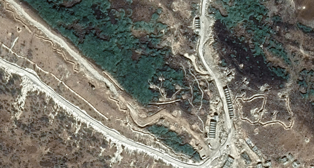
Doklam (Google Map)
Seven months after India stooped China from constructing a road in Doklam by sending troops to territory claimed by Bhutan, the People’s Liberation Army seems to have found a new route to the southern part of the plateau that overlooks the militarily-vulnerable Siliguri Corridor, The Print has reported.
According to the report, which is based on latest satellite imagery, China worked through the winter to create an alternate route over 4 km away from the Indian post located near the site of the 73-day face-off last year.
Images show that China constructed approximately a kilometre long road in January and almost 5 km in February southwards from a point where it has constructed three new helipads. The road, however, is not yet black-topped.
When complete, this route will give China access to Jampheri ridge that overlooks the strategic Siliguri corridor, also called ‘Chicken's Neck’. This narrow corridor connects India’s Northeast to other parts of the country.
China’s new route to south Doklam presents a new challenge for India because it lies deep inside the disputed territory. In comparison, the 2017 face-of site was reportedly 100 meters away from the nearest Indian post. The proximity of the site of road construction had made an Indian intervention easier.
Earlier this month, Defence Minister Nirmala Sitaraman had said that China is beefing up its presence in disputed Doklam by construction of helipads and developing other military infrastructure in the region.
Introducing ElectionsHQ + 50 Ground Reports Project
The 2024 elections might seem easy to guess, but there are some important questions that shouldn't be missed.
Do freebies still sway voters? Do people prioritise infrastructure when voting? How will Punjab vote?
The answers to these questions provide great insights into where we, as a country, are headed in the years to come.
Swarajya is starting a project with an aim to do 50 solid ground stories and a smart commentary service on WhatsApp, a one-of-a-kind. We'd love your support during this election season.
Click below to contribute.
Latest