Culture
India’s Legends Hold Clues To History, And Geology Testifies It; But Do We Care?
- Every region of India has its popular legends that have been orally handed down for millennia but are not documented anywhere. We ignore these at the peril of erasing our historical memory.
- The truth is not so much that our ancestors were a people with a poor sense of history but that we, in modern times, have an unjustifiably poor opinion of our sense of history.
Western coast of India
Indians face a double whammy. On one hand, there is the received wisdom that Indians have a poor sense of history and are appallingly poor at recording historical evidence. On the other, even career historians dismiss most of our ancient literature and popular legends out of hand as being pure fantasy, and unworthy of being regarded as a source of historical information. This is strange, considering that there were very few scribes in the past, and writing was extremely rare. Thus, apart from the sacred literature, unwritten oral tradition and popular legends were the only way to preserve and transmit knowledge. Also, it is baffling why India should be treated differently: but for Biblical legends, no one would have thought of archaeologically exploring Egypt or Mesopotamia, and their ancient civilisations would have remained undiscovered.
Many enduring legends may have a basis in historical events. In a stunning paper published in the leading journal, Science in 1975, top geologist of the University of Miami, Cesare Emiliani and his colleagues reported evidence of huge volumes of meltwater flowing down the Mississippi River into the Gulf of Mexico from the North American ice sheet around 11,600 years ago. The meltwater would have caused the sea-level worldwide to rise by 1-2 metres annually, inundating coastal areas where pre-and early agricultural populations were concentrated (owing to proximity to an easy source of food – fish). Their date tallied uncannily with that given by Plato for the deluge that destroyed the legendary Atlantis. While this may be a quirky coincidence, the actual episode itself may provide a basis for understanding how cultures as far removed as the Indian, Sumerian, Greek, Native Americans and Pacific Islanders all have their own flood legends – they are probably memories of historical events, embellished over time. A New York Times article covering this research can be read here.
There were many such events in the last 12,000 years (a period known as the Holocene), and such legends may refer to local deluges. China has its own flood legend. Only last year, researchers reported that its basis may lie in an earthquake that occurred around 1920 BCE, triggering a landslide, which caused the damming of the Yangtze River. Inevitably, this dam – estimated to be the size of the Hoover or Three Gorges dam – catastrophically burst a few months later.
Indians too have their flood legend, that of Vaivasvata Manu, which occurs in the Satapatha Brahmana of the Sukla Yajur Veda, and is repeated in the Mahabharata and the Puranas.
But it is not just flood legends that can be corroborated by geological investigations. There is the legend of Parasurama reclaiming land along the Konkan and Kerala coasts and settling people there. There is also the legend of Dwarka – possibly known to every child in India – being built by Krishna on land reclaimed from the sea, and which was eventually submerged in the sea in a cataclysm after his death. Then, there is the episode of the sage, Vasistha’s suicide attempt, which is not connected with the sea at all. As we shall see, geological data from the subcontinent may provide tremendous insight into the historical events which gave rise to these legends, and that these legends may not be merely flights of fantasy.
Vasistha’s Suicide Attempt, And How The River Sarasvati Saves Him
Vasistha’s persecution by Viswamitra for refusing to surrender his cow, Nandini, to the latter is well known. The Mahabharata describes how, when his son, Sakti dies through the agency of Viswamitra, the grief-stricken Vasistha attempts to end his own life in many different ways, but is always saved by the elements. Once, he tries to drown himself in the mighty river, Sarasvati, but the river saves him from the sin of suicide by splitting into numerous shallow streams. Sarasvati’s kindness proves timely, as the rescued Vasistha learns that his widowed daughter-in-law is pregnant, and he resolves to live so he can support her, and mentor her child, who turns out to be the great Parasara.
Geology tells us that the Sutlej was earlier a feeder stream of the Sarasvati (this was at least 5,000 years ago, no later), but subsequently changed course to join the Indus as a tributary, and, in the process, braided by splitting into many narrow channels. The ancient name of the Sutlej, Satadru literally means “hundred streams”. The archaeologist, D P Agrawal says the story of Vasistha’s suicide weaves in a vivid memory of this event, given the remarkable accuracy of the description. In his book, Ancient Cities of the Indus Valley Civilization, the University of Wisconsin archaeologist, Mark Kenoyer also cites this story as an example of how historians may have been overlooking helpful historical information contained in Indian religious texts when building their narratives of proto-historic India.
The Legend Of Parasurama Reclaiming The Kerala Coast
It is a very common legend that Parasurama reclaimed land from the sea in the Konkan and Kerala, and donated it to Brahmanas. Once again, the geological history of the Kerala coast suggests there could be more to this legend than colourful imagination. But first, a necessary detour.
Of Rising Sea Levels And Tectonic Events
The melting of ice caps from the last ice age resulted in a rise in the global sea level (technically called eustatic sea level) from a depth of about 120 metres about 18,000 years ago to what it is today. The rise was rapid at first, but slowed down considerably in the last 8,000 years after ice caps were left only in Iceland, Greenland and the Antarctic. In the last 6,000 years, the eustatic sea level became almost static. That should make things straightforward, shouldn’t it? Unfortunately, we have a complication.
Superimposed on the monotonically rising sea level is the effect of tectonic events, leading to rapid uplift or subsidence of land with respect to the sea level. In other words, the relative sea level in a particular region could fluctuate considerably. Shorelines may have moved several kilometres (km) inland, and back, and even back and forth many times. Thus, there were frequent episodes of marine transgression and regression, evidence of which has been reported from many places worldwide.
The Recent Geological History Of The Kerala Coast
The Kerala coast has seen multiple marine transgressions and regressions since the Last Glacial Maximum ( about 27,000 years ago). Even in the last millennium, when records are available, Kerala appears to have experienced a number of tectonic events. For instance, the now inhabited 14 km by 24 km island of Vypin near Kochi emerged in an earthquake which struck the coast in 1341 – the oldest recorded quake in the region.
A 2010 study of the Kerala coast found that the sea reached about 12 km inland about 7,000 years ago, and the environment subsequently changed from marine to brackish to freshwater, making it conducive for habitation. This not only implies a mid-Holocene marine transgression-regression cycle, but is significant as not every regression may lead to the place becoming habitable, as we shall see from the instance of the Rann of Kachchh below. Also, a 2015 study surmises, “…the sea level was between 3.5 and 4.5 m above present [mean sea level] during the Late Holocene period. ... the shoreline was about 3 km inland [about 4,000 years ago].… It may … imply the emergence of the coast due to neo-tectonic activity…”. Thus, the present day coast of Kerala probably emerged by rapid tectonic uplift in the last 4,000 years. The possibility of similar older tectonic uplifts having occurred between 4,000 and 7,000 years ago obviously cannot be ruled out, given the history of the region.
Now, Parasurama is definitely a historical personality and, as Jamadajna Rama (i.e., Rama, son of Jamadagni), is the composer of at least one hymn in the Rig Veda (10.110). It would appear the legend of Parasurama retrieving land from the sea may be based on an actual event of marine regression. Thus, it would be interesting to know when and how the peopling of this region happened. Archaeological discoveries will hopefully provide us some interesting answers to that question in the future.
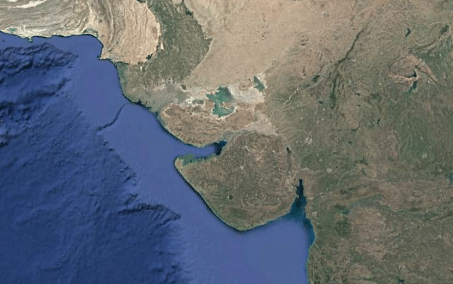
Dwarka
At the north-westernmost tip of the Kathiawar peninsula is the town of Dwarka, legendarily associated with Krishna. Krishna is believed to have reclaimed land from the sea for building Dwarka. Again, after his demise, the city is believed to have been cataclysmically swallowed by the sea.
Present-day Dwarka may go back only to Mauryan times. Offshore investigations also revealed many underwater structures and stone anchors, indicating an ancient port, now submerged. Significantly, on the island of Bet Dwarka, 30 km away, the former director-general of the Archaeological Survey of India (ASI), S R Rao discovered the remains of a late Harappan site, with settlement commencing at least about 1700 BCE. Rao himself believed he had discovered the historical Dwarka. However, there may be good reason to believe it may all go much further back in time than that.
The Eventful Geological History Of India’s Western Coast
The grand Harappan city of Dholavira in Gujarat was struck by a major earthquake around 2200 BCE. The city was surrounded by unusually thick walls, ostensibly to protect it from massive tsunamis, which seem to have deluged the Gujarat coast repeatedly, the earliest known one being from about 6000 BCE.
There is considerable geological evidence pointing to neotectonic events on the Saurashtra-Maharashtra coast, which may have led to rapid uplift or subsidence of land. Take the instance of the carbonate deposits off the Mumbai-Saurashtra coast. The remarkably even surface of this feature forms a submarine terrace, with a size three-quarters the area of Kerala, at a depth of about 90 metres (or fifty fathoms – a fathom is about six feet) from the sea level, giving it the name, fifty fathom flat (FFF).
(Incidentally, it is on the FFF that the Bombay High oilfield is located.) By dating the deposits, geologists found that shallow sea conditions prevailed on this platform about 8,300 years ago. However, at that time, the eustatic sea level was only about 25 metres lower than today (see figure 4.33 here), implying that this large feature subsided after about 6300 BCE owing to tectonic events. Similar indications of tectonic subsidence in the Holocene were also obtained from the submarine carbonate terraces (which are up to 2 km wide) on the continental slope off Saurashtra-Mumbai, found at depths greater than 100 metres (those interested in detail may see figures 2 and 3 here).
Equally, in this region, offshore dates from such submerged features like the FFF are at least 8,000 years old, while features like oyster reefs located a few metres above sea-level on the present-day shore too have yielded dates of about 8,000 years. Thus, one can safely conclude, the local sea-level had already reached, or slightly exceeded, the present day sea-level by about 6000 BCE. However, the eustatic sea-level then was at a depth of 24 metres from what it is today. This implies the coast had undergone a tectonic uplift around about 6000 BCE.
The local sea level on the Saurashtra coast reached a high somewhere in the mid-Holocene, when it was, in places, several metres higher than today. Many kilometres inland from the present-day shore were submerged, before the sea receded to its present level around 4000 BCE. The dates may vary based on local conditions, but such events seem to have been frequent in that region. For instance, the estuary region of the Mahi River that flows into the Gulf of Khambhat was submerged between 3,600 and 1,700 years ago owing to the higher sea-level, and later rose by subsequent tectonic uplift. Geologist Merh writes that “…the Holocene sea oscillated above and below the present level several times in the course of the last 6000 years”.
The Rann of Kachchh was under several metres of water till as recently as 2000 BCE. Dholavira, located in the Rann, probably served as a port, and went into decline when this function was lost with the sedimentation and uplift of the Rann. Many other Harappan ports – such as Lothal – too became dysfunctional in similar ways, and are today located several kilometres inland.
What makes these facts significant is the discovery – by oceanographers, not archaeologists – of a Neolithic city, possibly as old as the earliest known Indus Valley settlements at Mehrgarh or Bhirrana, submerged at a depth of 40 metres in the Gulf of Khambhat. This discovery could potentially rewrite the proto-history of the subcontinent, but not much further progress seems to have been made since its discovery in 2002, owing partially to India’s lack of expertise in marine archaeology, perhaps a lack of interest on the part of the successor to the Union minister then in charge, Dr Murli Manohar Joshi, and, majorly, to modern India’s disregard for its own history.
An episode of rapid uplift of land and marine regression may well be the historical basis for the legend of Krishna having reclaimed land from the sea for building Dwarka, just as its fabled destruction may be owing to an earthquake or tsunami.
The picture of India’s western coast today has clearly not always been the case throughout the Holocene, and is merely a snapshot in a complex evolution. The traditional account of Dwarka clearly has its origin in a vivid memory of historical events, as suggested by the wealth of geological evidence of frequent tectonic events leading to uplift and subsidence, massive tsunamis, and fluctuating sea levels, as well as the known impact such events had on Harappan cities of that region, and the fact that ancient cities have indeed been found submerged there. One can only hope the ASI enhances its capabilities in marine archaeology, and undertakes extensive, rigorous investigations off the western coast, for the exact location and historicity of Dwarka to be conclusively established.
Strikingly, traditional accounts and popular legends pertaining to distant regions of the subcontinent – The Sarasvati-Indus valley, coastal Gujarat and the Kerala coast – appear to have a basis in historical events, as suggested by geological data. For obvious reasons, the vital clues such traditional accounts provide in reconstructing the history of India have been deliberately ignored by prejudiced scholars who have monopolised the discourse for many decades now; anyone who challenges the status quo – and that includes even scholars of considerable stature – will immediately invite labels like anti-rational, “saffron” and “Hindutvavadi”, and get marginalised.
There are many other legends – notably that of Rama restraining the sea to build a bridge to Lanka – which could benefit from a systematic archaeological and geological investigation. How many readers know that surveys by the ASI and the Geological Survey of India have not been carried out for the Sethusamudram Project, even though they are mandatory by law for any such project anywhere in India? Every region of India has its own popular legends that have been orally transmitted for millennia, and are not documented anywhere. We ignore these at the peril of erasing our historical memory. The truth is not so much that our ancestors were a people with a poor sense of history, but that we, in modern times, have an unjustifiably poor opinion of our own sense of history.
Support Swarajya's 50 Ground Reports Project & Sponsor A Story
Every general election Swarajya does a 50 ground reports project.
Aimed only at serious readers and those who appreciate the nuances of political undercurrents, the project provides a sense of India's electoral landscape. As you know, these reports are produced after considerable investment of travel, time and effort on the ground.
This time too we've kicked off the project in style and have covered over 30 constituencies already. If you're someone who appreciates such work and have enjoyed our coverage please consider sponsoring a ground report for just Rs 2999 to Rs 19,999 - it goes a long way in helping us produce more quality reportage.
You can also back this project by becoming a subscriber for as little as Rs 999 - so do click on this links and choose a plan that suits you and back us.
Click below to contribute.
Latest