Heritage
Kedarnath Redevelopment: How Modi’s Pet Project Is Getting It Right On Tradition, Ecology and Development
- The 2013 Uttarakhand floods devastated the region around Kedarnath, nearly destroying the whole of Kedarpuri village.
- Modi has embarked on a pet project to redevelop the region. If things go according to plan, this would be a great example of heritage site redevelopment.
- The project gets nearly everything right: ecology, tradition, basic infrastructure and sanitation.
Kedarnath
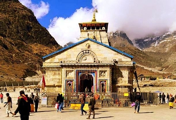
At 11,657 feet above sea level, Kedarnath is one of the most scenic and ethereal pilgrimage sites of Hindus. Steeped in legend and spirituality, records about this shrine date back to 6th century CE, when worship has been offered to Kedarnath almost continuously through.
The shrine may be lodged in the Himalayan valleys, but its head priest is traditionally from the Veerashaiva community down south in Karnataka. The shrine is even mentioned in Tamil bhakti works. Adi Shankara, born in today’s Kerala, one of India’s most influential philosophers, is said to have attained samadhi here.
Along with nearby Badrinath, this shrine is, perhaps, one of the hardest to visit as well. It would take a trek of 16 km for pilgrims to reach the temple.
The village of Kedarpuri, where the shrine stands, is today being redeveloped but much before the redevelopment was the 2013 floods that devastated the region, pulling down nearly every standing building in the village itself.
The project, along with restoration, will also ensure several key benefits and securities to the place. This is a pet project of Prime Minister Narendra Modi, enough reason for many to be relieved, and enough reason for several others to agitate.
After a disastrous management of the 2013 post-flood rehabilitation works by the then state government, it was imperative, with anyone who had his heart in the right place, to ensure the glory of one of the most revered seats of Mahadeva is restored.
And Modi is simply doing that. But before that, we’ll need to understand the terrain and the reasons behind the 2013 floods.
Kedarnath is situated at an elevation of 11,600 feet above Mean Sea Level, the highest among the char-dhams. Seated at the foot of Kedar dome, to the east of Mandakini river (originating from the Chorabari glacier), the temple had close to 7 lakh pilgrims visiting in 2018 (over 10 lakh pilgrims visited Badrinath in the same year) while a record 8 lakh pilgrims have already visited this year until the end of ashadha (pournimantya).
It is also the last inhabited place in that range which makes it a strategically significant location. This famous image from the 1860s shows the charm the place had, but not without human settlements. Kedarpuri is a village panchayat and has a permanent population.
The river Mandakini originates from the Chorabari glacier, which is quite vast, located Northwest of Kedarpuri. Mandakini flows in North-South axis, to the West of the temple. There is another major stream, river Sarasvati, which (probably) originates from a companion glacier adjacent to Chorabari glacier, and meets Mandakini upstream of the temple.
This is the new course of the Sarasvati, which earlier used to flow parallel to Mandakini to the east of the temple, and meets Mandakini after the temple. The reason for the change in course of the Sarasvati (it happened over the last few decades) is the over occupation of the river bed by buildings, so much so that She found a new way altogether to join Mandakini.
Sarasvati herself has a significant catchment area. It is intriguing to note that the name Sarasvati is commonly attributed to several streams, especially in the Himalayas. One more Sarasvati river (a tributary of Alakananda) can be seen upstream of village Mana, the last inhabited place in that range (upstream of Badrinath), the origin of which can be traced to a glacier near the Indo-Tibetan border. It is important to know the rivers located around Kedarpuri to understand the calamity that struck in 2013.
Another image (satellite) above puts the entire area into a proportional context. The glaciers are huge, and generally accumulates lot of sediments at the discharge point of the river. The oval in the image marks the entire Kedarpuri village in it. Another sketch below shows the extent of the glaciers that feed the Mandakini river system.
The Chorabari lake, the villain of the story, is one of the dozen glacial lakes that are part of the Mandakini river system from the upstream of Kedarpuri. The lake, 20 metres deep on an average, was originally attached to the snout of the glacier. However, due to continued receding of the glacier, the lake area only increased.
Along with that, thick moraine (unconsolidated glacial rock material which is quite unstable) walls also formed with every annual retreat of the glacier (Now, don’t jump to the conclusion that the glacier retreat is because of the human activity in Kedarpuri. The glacier retreat has been happening since the end of the ice age; it is because of this very reason that there are multiple lakes in the upper reaches of these mountains).
In the run-up to June 2013, the moraine build up had been the highest, as per the observations of the Wadia Institute of Himalayan Geology (WIHG), Dehradun (The Institute has meteorological observatory camps — one on Chorabari glacier and another a few km away to the East — with staff on site for most part of the year).
The lake is almost 2 km away from the temple but at an altitude higher by 700m. This gives you an idea about how steep and sudden the terrain was pre-2013. Post-the 2013 flooding, many had declared the lake to be ‘dead’. But there is a twist in the tale, explained later in the post. Also, it has been well established that the lake’s primary source is snow melting and monsoon rains.
The year 2012 saw the highest rainfall in five years in the valley. The state had hardly recovered from the devastation, thanks to the usual apathy of the governments. And then, 2013 knocked in.
Generally, if the rains start early in June, the probability of a high intensity precipitation in June itself is high. This is always the most damaging, considering a long dry spell which ends suddenly with heavy rains. The case with 2013, unfortunately, was this (there are good research papers explaining why the rainfall in June 2013, especially those 3–4 eventful days, was excessively heavy).
The eventful days of 16–17 June 2013 received some unusually heavy rainfall. The WIHG meteorological observatory at Chorabari Glacier camp (3820 m above MSL) recorded 210 mm rainfall in 12 hours between 15 June (5 pm) and 16 June (5 am) 2013. On 16 June 2013 alone (from 5 am to 5 pm), 115 mm rainfall was recorded, causing 325 mm rain in 24 hours.
Such a heavy rainfall coupled with low atmospheric pressure fed the lake, so much so that the lake increased its level by almost 7 m. Adding to it, the glacier started melting as well. The moraine wall that had formed between the glacier and the lake gave away under extreme pressure from the precipitation collected in the glacier.
The Mandakini valley beyond Kedarpuri assumes a steep decline with the valley assuming a narrow space. This continues till Sonprayaga after which the valley widens and the gradient also flattens. See below image for a perspective.
The heavy rainfall effecting the glaciers and the lake had two devastating consequences.
The first event that occurred on 16 June evening started with heavy flooding of Sarasvati due to incessant rains that started from 15 June. Post-event satellite images show that all channels — old and new — were charged heavily. The old channels as such were filled with sediments and the new ones also carried huge sediments (boulders) of the size of a few metres in diameter.
This voluminous discharge hit the north of Kedarpuri, damaging Adi Shankaracharya samadhi, Bharat Sevashram, and other buildings located close to the old course of the Sarasvati. Dobhal et. al. note that this has been the ‘biggest devastation’ recorded ever until that time.
The north part of the village was completely washed away by this event. The heavy downpour with high sediment discharge on a steep gradient in the narrow valley gushed towards Rambara, as if it was a boulderfall on the place and destroyed it completely, on 16 June evening.
The second event, as per Dobhal et. al., occurred the very next day, 17 June. The incessant rains had built up huge storage of water in the lake that was dammed by structurally unstable moraine as explained earlier. The rains also caused a rapid melting of snow accumulated on the upper reaches of glacier by a few feet which added enormous volumes of water to the lake over three days.
The stress on the moraine barrier was unbearable and it finally gave away on early morning of 17 June. This released an unimaginable volume of water along with sediments into Mandakini.
The Chorabari lake breach made the lake empty over 300 millions litres of water with high potential energy within a few minutes (the lake is barren now as the debris from glacier has filled the entire depth of the lake; some experts say that it might even take a century for the lake to come alive again).
A study by Geological Survey of India recorded the rise in the river level was of the order of 5–7 m, where the valley was wide and 10–12 m where the valley was narrow. This event devastated not only Kedarpuri, but Gaurikund, Sonprayaga and Phata through to Byung also experienced a never recorded devastation.
The sudden discharge of enormous volume of water also induced hill toe erosion along all the river valleys. This in turn triggered many landslides in the valley. What followed these events was an unprecedented loss of life and property, and a monumental rescue effort by the defence forces, but miserable relief efforts by the then governments.
It was not an easy situation.
The scar left by 2013 on the psyche of Uttarakhand and people from other states who lost their near ones is deep and hardly erasable. It was with this background and a proven track record of disaster management (especially post-disaster rehabilitation) that Modi decided to take up restoration and redevelopment of Kedarpuri.
Shri Kedarnath Utthan Charitable Trust was mandated to exclusively take up the restoration task. A big corporate also pitched in as part of its CSR to develop the place. The key objective was to have a flood-proof protection for the entire Kedarpuri village.
Broadly, the construction activities include meditation caves, a memorial at the foothills, road widening and construction, building ghats and retaining walls along the Sarasvati river.
Apart from these, the project also includes Kedarpuri central approach street being widened, Adi Shankara’s samadhi and virtual museum, guest houses, housing units for teerth purohits in Kedarpuri, laser/light shows and building an arrival plaza.
More importantly, the project also includes building retaining structures capsuling the entire Kedarpuri.
The only item that causes discomfort to a traditionalist is the laser/light and sound show. This must be avoided — there is no place for such a thing which does not gel with the sanctity of the place.
Road widening and building new roads (read widened foot paths) are necessary as the earlier one had been completely destroyed in 2013. The new path being built takes care of slope protection and drainage, which were missing previously.
Ghats and associated retaining walls make for a great initiative simply because it was highly challenging to reach the rivers previously as there were no steps to them. With properly planned steps, one can feel the waters of the Mandakini and the Sarasvati.
Going to an ancient kshetra and not having to feel the rivers there? Not done.
A few guest houses are also being built. These guest houses will come up in a planned way, in the place of old haphazard buildings. These guest houses are not for promoting tourism.
Anyone who has visited the place will have an idea of the critical role the weather plays. It is important that the pilgrims are protected from harsh conditions. Pilgrims who would reach this place mostly by trekking several kilometers of tough terrain need to rest and have a bath before the darshan of Shri Kedarnath. These guest houses provide those facilities.
To avoid crowding of the place, the approach has been made much wider, after clearing the huge encroachments around the temple. There is a large circular arrival plaza, which acts as a place for pilgrims to sit and rest and wait for their turn to proceed to the temple.
This plaza and widened approach coupled with the much wider jagati around the main temple structure makes it a seamless experience for darshan to devotees. Token system for controlling the crowd has also been experimented with, this season.
The approach to temple was packed with shops and hotels earlier, most of which were washed away in 2013. These buildings hindered the view of the temple. The project has now ensured that the view of the temple is clear even from afar. The entire new construction of guest houses, housing units, ghats are planned to come up on an elevated platform, respecting the rivers’ courses and bed areas.
For example, consider the retaining walls being built. The buttress structural wall made of concrete along with the a gabion wall structure will help prevent any flow of debris into Kedarpuri. The wall system will also help divert any sudden and large flows of debris and water towards the proper course of the rivers. The wall system is also intended to avoid any cross flow of rivers into Kedarpuri. In addition, the wall system acts as an energy dissipator by slowing down the discharge to an extent.
Some have used the building of walls as an excuse to go after the project, stating that a dead lake upstream means you don’t need flood protection anymore and so on. Guess what, there are unverified (as yet) reports of the lake coming back to life.
The project involves building the never existent utilities — a key component of any human habitat — building such basics now gets called building something smart! These are all-weather, high-capacity utilities aimed at sustaining the place even in peak winters.
There were only two low-rated substations all this while (even they were devastated in 2013) and now five 63 and 100 kVA substations are being added. All power cables are being laid underground, which is how it should be done.
A robust sewage network is also being built — all underground and no open drains. The sewage from the entire village will be collected at the southern most point of the village at the pumping station and pumped down the place to the disposal/treatment plant.
Plans are made for effective collection and disposal of solid waste. A separate storm water network is being built. In many parts of the country, sewage and storm water network are the same, but it will not be the case in Kedarpuri. Only the storm water is allowed into the rivers. A sturdy underground potable water network is being laid too. A public address system and CCTV networks at key points are being installed. The required OFC is also being laid underground.
The general plan of Kedarpuri redevelopment and how far it has been implemented till date can be seen in the below two images.
The Adi Shankara samadhi that was washed away is being rebuilt at the same location, with enhanced protection. There will be a virtual museum on Sankara’s life and works in the same complex. The yellow shaded blocks in the planned layout are the guest houses.
The other dark grey blocks are the housing units for the purohitas (unlike most other temples, there are a couple of dozens of purohitas here (the pramukh-purohita, Raval, hails from Karnataka and other purohitas are mostly locals).
They hail from the villages in the upper reaches of the Mandakini valley. Lamgondi, Singoli, Guptakashi are some of the places the purohitas come from, who have been spending the whole of the yatra season at Kedarnath for pourohitya for several generations now.
The only income for the whole of the year for most of these families has been the dakshina offered by pilgrims in the yatra season. In non-yatra months, some purohitas go on pilgrimages on the invitation of devotees. Times are changing, more younger ones are venturing out on ‘technical’ jobs in the plains now than ever before.
The place is the last inhabited settlement in the range towards the Indo-Tibet border. It is extremely important from the strategic point of view to have an infrastructure that facilitates quick movement of forces towards the border.
Also, even in case of an emergency-like situation arising out of nature’s courtesy, it is important to quickly evacuate the pilgrims from the place. Hence, repairing the already existent helipads was key. The forces (mainly ITBP) are present through out the year, including the harsh winters. It is only logical to meet the best of their requirements.
What is evident by now is that Modi’s pet project of redevelopment of Kedarpuri is a great initiative involving the best of disaster management plans, creating more open spaces around the temple and in the village, respecting the might and preserving the natural courses of the Mandakini and the Sarasvati, facilitating pilgrims to have darshan without having to face hassles due to inefficiency of the administration.
The temple is said to have been consecrated by the Pandavas and (re)built by Adi Shankara who attained samadhi there.
Does this redevelopment change or reduce any of the traditions associated with the temple?
Even after 2014, the pallaki carrying the festive murti of Kedarnath starts from Ukhimatha (Ushamatha), his winter abode, some 60 km downstream, with the Army joining the procession amid veda-mantras and traditional music.
Even after 2014, the pallaki travels on the shoulders of local devotees under the direction of the Raval with other purohitas chanting the mantras.
Even today, the pallaki halts at specific locations and obeisance paid as prescribed by the tradition. Even after 2014, the opening and closing of portals at the temple, and the associated yatras to and from Ukhimatha — Kedarpuri, the pooja-archana at the temple happen exactly as they have been happening since ages — be it rains, floods or landslides.
The sanctity of the yatra is not compromised with even a bit. If anything, the project has only added to the beauty and sanctity of the yatra and the place.
There is an argument that the project is detrimental to the ecology. The argument is as vacuous as the argument of sanctity being compromised.
The fact that human intervention and interaction with the rivers have been drastically reduced by means of clearing the buildings off their original course, and that proper ghats are being constructed shows how the respect the rivers ought to be given is being given.
The fact that sewage and solid waste management plans are being implemented, and the fact that the whole area will be litter-free is the respect that the project offers to the environment there.
The fact that proper ablution units are being built as part of the guest house and housing units shows the sincerity in inducing sanitation in pilgrims. Most part of the construction happening are using materials that are naturally available — boulder sediment that is abundantly made available especially after 2013, wood, etc.
In fact, the design of the purohita housing units and guesthouses are based on Uttarakhand’s traditional building principles and more importantly, keeping the area’s seismic sensitivity in mind.
The five-year long project when completed (scheduled in 2022) will present an excellent model for development of Hindu religious places while maintaining the traditions, pious nature of the place at the same time.
A fuller version of this article has been published here.
Support Swarajya's 50 Ground Reports Project & Sponsor A Story
Every general election Swarajya does a 50 ground reports project.
Aimed only at serious readers and those who appreciate the nuances of political undercurrents, the project provides a sense of India's electoral landscape. As you know, these reports are produced after considerable investment of travel, time and effort on the ground.
This time too we've kicked off the project in style and have covered over 30 constituencies already. If you're someone who appreciates such work and have enjoyed our coverage please consider sponsoring a ground report for just Rs 2999 to Rs 19,999 - it goes a long way in helping us produce more quality reportage.
You can also back this project by becoming a subscriber for as little as Rs 999 - so do click on this links and choose a plan that suits you and back us.
Click below to contribute.
Latest