Insta
Video, Satellite Images Show Chinese Army Has Built A New Base Near India-Nepal-China Trijunction; Troops, Equipment Moved In
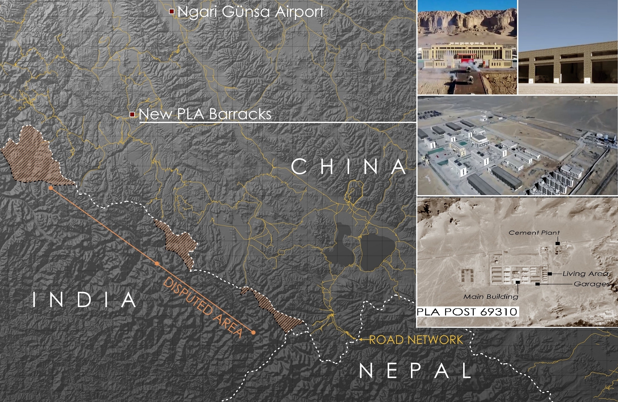
An infographic posted on Twitter by @detresfa_.
The Chinese Communist Part’s People’s Liberation Army (PLA) has inaugurated new barracks near the India-Nepal-China trijunction.
The new Chinese camp is located at an elevation of around 4,000 feet and lies roughly within a 100-kilometer radius of the India-China border.
The Chinese base, called Post 69310, lies north of Uttarakhand.
The new Chinese base covers an area of 0.66 square kilometers. Construction of this facility in Tibet began in July 2019.
The Chinese airbase in Nagri Gusan, located close to the new army camp, has also been upgraded recently.
Satellite images dated 15 May, posted by an open-source intelligence handle on Twitter, show rapid construction parallel to the runway since April 2020. Reports say it could be a “second taxi-track or a secondary tarmac”.
Fighter jets of the People’s Liberation Army Air Force (PLAAF) were seen deployed at the airbase. Four PLAAF, possibly J-11s or J-16s, were seen at the base.
While the upgraded airbase is around 200 kilometers away from the Pangong Tso, the new Chinse base is nearly 250 kilometers away from the lake.
A video put out by the Chinese media outlets shows soldiers moving into the base along with mechanised and logistics units.
While India and China have exchanged maps (based on their perceptions and claims) of the central sector (Tibet’s boundary with Uttarakhand and Himachal), multiple Chinese transgressions have been reported in the area over the years. The Chinese have also violated Indian air space in the area multiple times.
Interestingly, the area in which the Chinese camp has come up is also located close to the Indian territory that Nepal claims as its own.
Earlier this year, the Communist Party government in Kathmandu, led by K P Sharma Oli, revised the country’s map through a constitutional amendment to include Indian territory in Uttarakhand’s Pithoragarh district.
Support Swarajya's 50 Ground Reports Project & Sponsor A Story
Every general election Swarajya does a 50 ground reports project.
Aimed only at serious readers and those who appreciate the nuances of political undercurrents, the project provides a sense of India's electoral landscape. As you know, these reports are produced after considerable investment of travel, time and effort on the ground.
This time too we've kicked off the project in style and have covered over 30 constituencies already. If you're someone who appreciates such work and have enjoyed our coverage please consider sponsoring a ground report for just Rs 2999 to Rs 19,999 - it goes a long way in helping us produce more quality reportage.
You can also back this project by becoming a subscriber for as little as Rs 999 - so do click on this links and choose a plan that suits you and back us.
Click below to contribute.
Latest