Insta
With Two New Union Territories, Here Are The Latest Political Maps Of India Released By The Indian Government
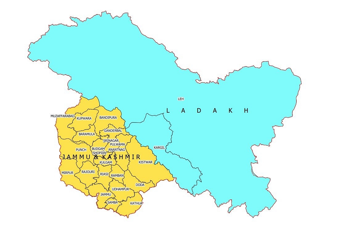
MAP OF UT OF JAMMU & KASHMIR AND UT OF LADAKH. (as per government release)
With the twin Union Territories (UTs) of Jammu & Kashmir and Ladakh coming into existence from 31 October (Thursday) through the Jammu and Kashmir Reorganization Act, 2019 the political map of the country has also undergone a change.
The new political maps of India and new UTs have been released by the government to mark the development.
The new Union Territory of Ladakh consists of two districts of Kargil and Leh. The rest of the former State of Jammu and Kashmir is in the new Union Territory of Jammu and Kashmir.
In 1947, the former State of Jammu and Kashmir had the following 14 districts - Kathua, Jammu, Udhampur, Reasi, Anantnag, Baramulla, Poonch, Mirpur, Muzaffarabad, Leh and Ladakh, Gilgit, Gilgit Wazarat, Chilhas and Tribal Territory.
By 2019, the state government of former Jammu and Kashmir had reorganized the areas of these 14 districts into 28 districts. The names of the new districts are as follows - Kupwara, Bandipur, Ganderbal, Srinagar, Budgam, Pulwama, Shupian, Kulgam, Rajouri, Ramban, Doda, Kishtivar, Samba and Kargil.
Out of these, Kargil district was carved out from the area of Leh and Ladakh district. The Leh district of the new Union Territory of Ladakh has been defined in the Jammu and Kashmir Reorganization (Removal of Difficulties) Second Order, 2019.
Support Swarajya's 50 Ground Reports Project & Sponsor A Story
Every general election Swarajya does a 50 ground reports project.
Aimed only at serious readers and those who appreciate the nuances of political undercurrents, the project provides a sense of India's electoral landscape. As you know, these reports are produced after considerable investment of travel, time and effort on the ground.
This time too we've kicked off the project in style and have covered over 30 constituencies already. If you're someone who appreciates such work and have enjoyed our coverage please consider sponsoring a ground report for just Rs 2999 to Rs 19,999 - it goes a long way in helping us produce more quality reportage.
You can also back this project by becoming a subscriber for as little as Rs 999 - so do click on this links and choose a plan that suits you and back us.
Click below to contribute.
Latest