News Brief
Explained: Why China’s New Dam On Brahmaputra May Not Cause Water Shortage In Northeast But Is Still A Concern For India
- The fear that the construction of a dam in Tibet would choke off the Brahmaputra and cause severe water shortages in India’s northeast is not based on facts.
- The Brahmaputra is not entirely dependent on upstream flows from Tibet.
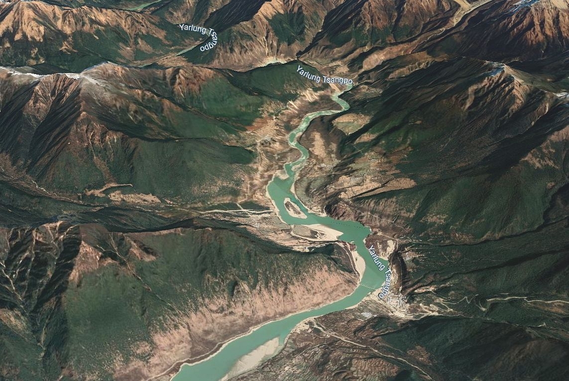
Yarlung River
China's toothless supreme legislative body, the National People's Congress (NPC), on Friday approved the outline of its 14th Five-Year Plan (2021-2025), which involves, among other things, a plan to build a new dam on the lower reaches of the Yarlung Zangbo River in Tibet, called the Brahmaputra in India.
China’s plan for a new dam has sparked concerns in India, especially in Assam, and Bangladesh, the lower riparian states.
The apprehension in India and Bangladesh is that the construction of the dam in the lower reaches of the river, or at the Great Bend, where the river turns sharply and enters Arunachal Pradesh, could ‘choke off’ the flow of the Brahmaputra, resulting in severe shortage of water in the lower riparian states.
The Chinese Communist Party’s reckless disregard for environmental conservation and the consistent denial of the ecological fallouts of its mega projects on the Tibetan Plateau in the past has aggravated the concern.
While the latter is a legitimate concern, the former not so much.
Brahmaputra not entirely dependent on upstream flows from Tibet
The fear that the construction of a dam on the Yarlung Zangbo in Tibet would choke off the river and cause severe water shortages in India’s northeast is not based on facts, which suggest that a very large part of the total annual flow of the Brahmaputra is generated in the southern aspect of the Himalaya in India.
Of Brahmaputra’s total length of 2,880 kilometre, nearly two thirds or about 1,625 kilometre lies on the Tibetan Plateau. This has led to the widespread belief that the river receives the largest share of the total discharge on the Tibetan Plateau.
Before entering Arunachal, Yarlung is mostly fed by snow and glacial melts on the Tibetan Plateau. However, the Normalized Melt Index or NMI, which is defined by experts as the volumetric snow and glacier upstream discharge divided by the downstream natural discharge, is in the range of 0.15-0.2 for the Brahmaputra.
This, as Dr. Nilanjan Ghosh, Director, Observer Research Foundation Kolkata points out, shows that the snow and glacial melts, the main source of run-off for the Yarlung in Tibet, contribute very little to the total flow of the Brahmaputra.
A large part of the Tibetan Plateau lies in the rain shadow because the Himalayas act as an orographic barrier to the rain-laden monsoon winds of the Bay of Bengal — annual precipitation in this region averages about only 300 millimetre. On the Indian side, average annual precipitation reaches nearly 2,000-3,000 millimetre.
Data published by Chinese scholars and cited by Ghosh shows that Yarlung’s total annual outflow from China is about 31 Billion Cubic Metre (BMC). However, the annual flow of Brahmaputra at Bahadurabad gauging station in Bangladesh, close to the point where the river enters the country, is about 606 BCM.
At Nuxia and Tsela Dzong water measuring stations in Tibet, the peak flows during the monsoon season are about 5,000 and 10,000 cubic metre per second. But downstream in India, the peak flow increases, reaching around 40,000 cumes in Guwahati and 50,000 cumecs in Bangladesh’s Bahadurabad.
In the lean season, the flow in Tibet at Nuxia is 300 to 500 cumecs, while the flow in India at Guwahati is around 4000 cumecs.
This suggest that the contribution of snow and glacial melt to the flow of the river is high in the the upper reaches but low in the overall stretch.
The Brahmaputra gets a large part of its flow downstream, as it is joined by a number of large eastern and western tributaries like Dibang, Luhit, Subansiri, Manas, Sankosh and Teesta, which contribute significantly to the flow of the river.
This is why the construction of a dam by China in the upper reaches of the Yarlung on the Tibetan Plateau has not caused significant water shortage in the Brahmaputra downstream in India and Bangladesh. But now, China plans to build a dam in the Medog County of Tibet or at the Great Bend, close to the point where the river leaves the Tibetan Plateau and enters Indian territory.
Tibet’s Medog county lies in the south aspect of the Himalayas and a tributary called the Parlung joins the Yarlung here, increasing the river’s flow. The Medog county, which lies near the Great Bend, also receives an annual average precipitation of 3,000 mm, almost similar to the average annual precipitation on the Indian side and much higher than the 500 mm recorded at Tibet’s Nuxia.
In other words, the flow in the Yarlung river increases (in comparison to its upper reaches in Tibet) towards the end of its journey on the Tibetan Plateau.
This means that the amount of water flowing into Indian territory from the Tibetan Plateau may be small but can’t be called negligible.
“...in percentage terms, the contribution emerging from the Chinese boundary to the immediate point in the Indian boundary cannot be stated to be negligible, though this turns out to be of not much significance to the run-offs in the Assam floodplains in India or the Jamuna floodplains in Bangladesh,” Ghosh writes.
China plans to use this increased flow in the Yarlung river near Medog or at the Great Bend for the generation of hydroelectricity.
What a dam near the Great Bend means
Short of causing a water shortage, the construction of the dam will have many adverse impacts on the downstream flow and, as a result, the riverine ecosystem.
A dam at the Great Bend or somewhere in and around Medog country could significantly alter the flow regime in the downstream.
China is unlikely to go for a run-of-the-river hydro power project, one that does not involve large-scale water storage and may not significantly alter the flow regime. The flow of water in the Yarlung river during the lean season may not be sufficient to run the hydro power plant at installed capacity.
If China builds a large reservoir of water to run the hydro power plant, there could be some impact on the level of water in the stretch of the river in Arunachal Pradesh. Only the environmental flow — quantity of water necessary to sustain aquatic ecosystems — might get released in the river.
“As a result, the Yarlung/Siang will have relatively less water during a few hours of the day representing the minimum flow conditions of the year, while for the rest of the day, it could represent the monsoonal flow of a uniform nature for as long as the units/turbines generate hydropower,” explains Sayanangshu Modak, a Junior Fellow at ORF's Kolkata centre, in a recent piece.
But the impact may not be felt further downstream after Sadiya, where three tributaries, Luhit, Dibang and Dihang, join (to form the flow that is called Brahmaputra).
The construction of the dam will significantly alter the flow regime downstream due to hydropeaking — discontinuous release of turbined water to satisfy peaks in electricity demand that are subject to fluctuations during the day.
Hydropeaking causes artificial rapid fluctuations in downstream river flow and could adversely impact riverine ecosystems, water temperature, sediment composition and the rate of sediment transport in the river.
Add to this the fact that the region where China plans to build the dam is prone to landslides and avalanches which could lead to flash floods. The average annual frequency of such hazardous events in the region is between 10 to 15.
Such events could also lead to dam burst, which could cause significant damage immediately downstream in Arunachal Pradesh.
Support Swarajya's 50 Ground Reports Project & Sponsor A Story
Every general election Swarajya does a 50 ground reports project.
Aimed only at serious readers and those who appreciate the nuances of political undercurrents, the project provides a sense of India's electoral landscape. As you know, these reports are produced after considerable investment of travel, time and effort on the ground.
This time too we've kicked off the project in style and have covered over 30 constituencies already. If you're someone who appreciates such work and have enjoyed our coverage please consider sponsoring a ground report for just Rs 2999 to Rs 19,999 - it goes a long way in helping us produce more quality reportage.
You can also back this project by becoming a subscriber for as little as Rs 999 - so do click on this links and choose a plan that suits you and back us.
Click below to contribute.
Latest