Science
Bengaluru Startup Pixxel Shares Hyperspectral Images From Its Satellites In “Major Milestone"
- Pixxel aims to provide a comprehensive view of the earth with its hyperspectral imaging satellite constellation.
- Their big idea is to build a round-the-clock health monitor for the planet.
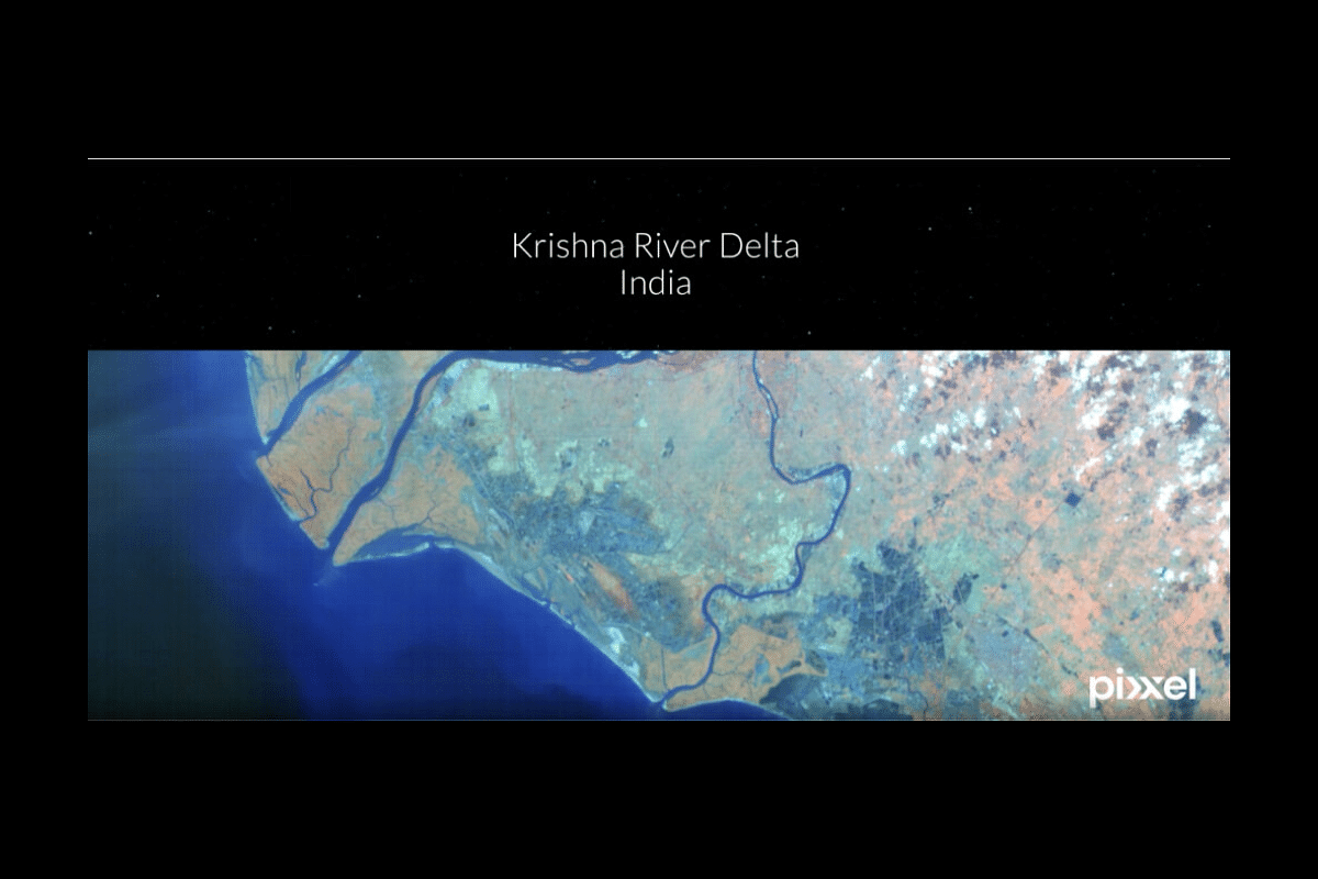
The Krishna river delta, as snapped by a Pixxel hyperspectral satellite
Indian space technology company Pixxel has shared the first images from its pathfinder satellites.
“These images mark a major milestone,” the company said in a tweet.
The video on Pixxel’s tweet gives glimpses of its various captures, including the Krishna river delta in India, the Palm Islands of Dubai, and the Saloum river delta in Senegal. The individual pictures are shared on the company blog.
The “hyperspectral samples” can be accessed after filling up a form to join Pixxel’s “early adopter program.”
Pixxel is based in Bengaluru, India, and California, the United States. Last year, and just in one year alone, it launched three pathfinder missions into orbit, including Shakuntala and Anand.
The space data startup had its first space launch with American aerospace company SpaceX when its hyperspectral imaging satellite “Shakuntala” was placed in low-Earth orbit in April 2022.
Its third hyperspectral satellite, called Anand, took its place in space after India’s polar satellite launch vehicle (PSLV) shot up for its 56th mission called “PSLV-C54/EOS-06.”
The job of the technology demonstration satellite was to go up in orbit and then beam down good quality data from space, which essentially translates to pictures of the Earth.
Anand was supposed to fly on board the PSLV-C51 mission on 28 February 2021. But the company stood down from launch five days prior due to the emergence of software issues during the final satellite testing.
It got its next launch shot over 18 months, and very many retests, later, and the reward for it has come now, about two years after its first scheduled launch, in the form of images.
Domains such as agriculture, oil and gas, urban monitoring, climate control, and forestry are said to benefit from such satellite data and images.
“The images will help unearth unseen problems that are invisible to satellites in orbit today and enable sectors to make more informed and evidence-backed decisions related to global phenomena,” Pixxel’s founder and chief executive officer, Awais Ahmed, wrote in a blog post.
Shakuntala is capable of capturing orbital images in more than 150 bands of colour from the visible and infrared spectrum with a resolution of 10 metres per pixel.
The images can capture and highlight, in sharp detail, features like soil types, mountain ranges, bare lands, agricultural farms, and urban settlements, among others.
“Pixxel now has the highest resolution hyperspectral capacity that we’re beaming down and sharing with our customers,” he wrote, adding that they were making progress “towards completing a constellation of the world’s highest-resolution hyperspectral earth imaging satellites as well as an AI-powered analytics platform.”
Pixxel’s upcoming constellation of 24 satellites is scheduled for launch in 2024-25.
Their big idea is to build a round-the-clock health monitor for the planet.
Support Swarajya's 50 Ground Reports Project & Sponsor A Story
Every general election Swarajya does a 50 ground reports project.
Aimed only at serious readers and those who appreciate the nuances of political undercurrents, the project provides a sense of India's electoral landscape. As you know, these reports are produced after considerable investment of travel, time and effort on the ground.
This time too we've kicked off the project in style and have covered over 30 constituencies already. If you're someone who appreciates such work and have enjoyed our coverage please consider sponsoring a ground report for just Rs 2999 to Rs 19,999 - it goes a long way in helping us produce more quality reportage.
You can also back this project by becoming a subscriber for as little as Rs 999 - so do click on this links and choose a plan that suits you and back us.
Click below to contribute.
Latest