Science
ISRO Satellite's Earth Images From February Are A Sight For Sore Eyes
- The Indian space agency processed 300 GB of data to show Earth as it was, though in "false colour," between 1 and 15 February 2023.
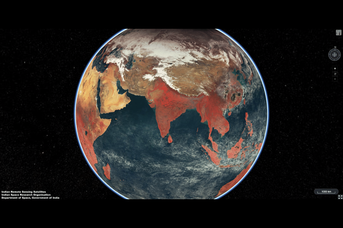
One of the Earth images shared by ISRO shows India in glorious view. (Photo: ISRO/Twitter)
A scientific instrument on an Indian Space Research Organisation (ISRO) satellite has helped throw up gorgeous images of planet Earth, including that of India.
Very many images, snapped by the Ocean Colour Monitor (OCM) on board the Earth Observation Satellite EOS-06, were put together to form a mosaic with 1-km spatial resolution.
The National Remote Sensing Centre generated the "false colour composite" (FCC) mosaic (explained later) by combining 2,939 individual images, ISRO said.
They processed 300 GB of data to show Earth as it was, though in "false colour," between 1 and 15 February 2023.
False Colour?
"False colour" refers to the fact that the colours on the images don't accurately reflect the "true" colours that humans would see if they got a firsthand view of the subject.
That is why sometimes, in such images, the forest appears red or the cloud blue. The red (R), green (G), and blue (B) values do not correspond to the true colors of red, green, and blue.
But, then, why the false colour?
NASA Earth Observatory explains: "Satellites collect information beyond what human eyes can see, so images made from other wavelengths of light look unnatural to us. We call these images “false-color,”..."
The OCM, behind the images which eventually helped shape the lovely Earth mosaic, senses our home planet in as many as 13 distinct wavelengths!
As a result, scientists get information about vegetation cover on land and ocean biota for oceans worldwide.
False colours principally help to emphasise certain features, such as vegetation cover, over others, depending on the purpose of the satellite and the images it's setting out to capture.
EOS-06 Satellite
The OCM (OCM-3, to be exact) sits alongside the Sea Surface Temperature Monitor (SSTM), Ku-Band Scatterometre (SCAT-3), and ARGOS as the payloads on ISRO's EOS-06 satellite.
EOS-6 is the third-generation satellite in the Oceansat series. It took off on a polar satellite launch vehicle (PSLV) from Satish Dhawan Space Centre, Sriharikota (SDSC-SHAR) nearing noon on 26 November 2022.
The launch of three satellites by two Indian space technology companies Pixxel and Dhruva Space headlined that PSLV-C54/EOS-06 mission which also placed the under-the-radar Oceansat-3 in orbit.
Fortunately, Oceansat-3 has been enthralling us with occasional image dispatches from as early as within the first week of its launch.
The Himalayas, the Gujarat Kutch region, and the Arabian Sea were seen in the day-one images, courtesy the OCM-3 and SSTM.
They were received at NRSC, Shadnagar, on 29 November and shared with the public the next day.
The satellite's capture of cyclone Mandous came next, in early December, along with the identification of algae (coccolithophore) bloom off the coast of Argentina in the South Atlantic Ocean, again thanks to the OCM-3.
Support Swarajya's 50 Ground Reports Project & Sponsor A Story
Every general election Swarajya does a 50 ground reports project.
Aimed only at serious readers and those who appreciate the nuances of political undercurrents, the project provides a sense of India's electoral landscape. As you know, these reports are produced after considerable investment of travel, time and effort on the ground.
This time too we've kicked off the project in style and have covered over 30 constituencies already. If you're someone who appreciates such work and have enjoyed our coverage please consider sponsoring a ground report for just Rs 2999 to Rs 19,999 - it goes a long way in helping us produce more quality reportage.
You can also back this project by becoming a subscriber for as little as Rs 999 - so do click on this links and choose a plan that suits you and back us.
Click below to contribute.
Latest