Science
The Jyotirlingams Of Mahakaleshwar And Omkareshwar – Some Astounding Facts About Their Sacred Geographies
- What we know certainly is that the Mahakaleshwar of Ujjain lies at the centre of the strongest gravity anomaly in the subcontinent.
- Just as the Omkareshwar marks the very point on the Narmada where old Precambrian rocks surface in swayambhu fashion from below far younger Deccan Traps.
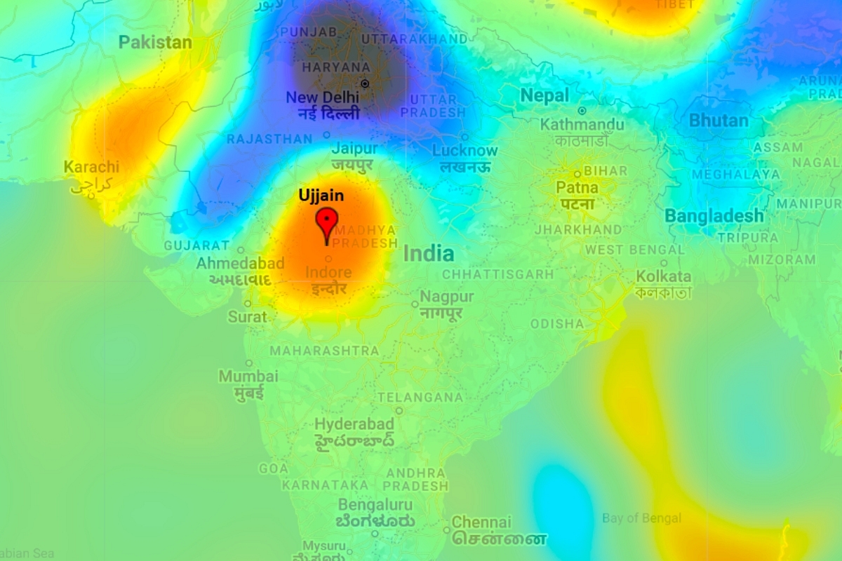
Ujjain's location in a map of gravity anomalies in India.
A key characteristic of the Indian civilization is the concept of a sacred geography. By it, certain locations, and geographical features like mountains or rivers, are accorded a special sanctity. The reasons are usually obscure, and lost to time. Nonetheless, it is a fact that every corner of the subcontinent has its sacred spots, which, cumulatively, outline the boundaries of an ancient nation.
They range from countless village temple groves which used to dot the land, but have so sadly fallen of late to the hand of man, to mighty rivers and soaring mountains. They may be curves in a river, like Kashi, on the Ganges; or halting points on major trade routes, like Maheshwar on the Narmada; or historic cities like Dwaraka, an ancient gateway to India for traders from the west.
Many of these locations have remained as major pilgrimage centres for millennia now, with visits by devotees continuing in an unbroken cycle of devotion and salvation, even through the horrific, sustained depredations of the last millennium. Now, we can but speculate on why these places came to acquire a special status so long ago, and why they continue to attract such widespread reverence even today.
Perhaps this sacred geography reflects the true degree to which we are bound to our land, and represents the essence of our way of life – a need to maintain the natural order of things. Perhaps it also underscores a deeply spiritual rationale for a greater reality – that it is humans who have to maintain harmony with nature, and not the other way around.
Of course, there are many today who scoff at this concept. To them, such sentiments only mirror meaningless pagan practices with no scientific basis. There are no tree spirits to be found in sacred groves; in fact, there are no tree spirits at all. A yakshi is precisely the reason why Marx is right – that religion is the opium of the masses. And anyone lauding the divinity of the Indus is actually a fascist, majoritarian, Islamophobic, Hindutvavadi, hell bent on resurrecting an Akhand Bharat.
And yet, that same science, which our deracinated intellectuals employ to mock us and our zany ways, now offers intriguing insights into our sacred geography. Maybe, just maybe, there’s more to these places than meets the eye. Therefore, this piece will unveil hitherto unknown facts about two revered spots in Central India – the jyotirlingas of Mahakaleshwar at Ujjain, and Omkareshwar on the Narmada.
The Mahakaleshwar at Ujjain
The Mahakaleshwar Shiva temple of Ujjain lies beside the river Kshipra in southern Madhya Pradesh, atop the Malwa plateau. It is located on the Tropic of Cancer. The region’s bedrock is dense basaltic rock, formed by massive lava flows which occurred at the fag-end of the Cretaceous period, around 70 million years ago. These basalts are colloquially known as the Deccan Traps, and cover much of peninsular India.
History teaches us that Ujjain was already a bustling city at least 2600 years ago, and the capital of the Avanti mahajanapada – one of 16 principal kingdoms and republics which flourished around the time of The Buddha and Mahavira. Its presiding deity has been Shiva, called Mahakaal, or the lord of time, for most of recorded history.
The Surya Siddhanta, a remarkable astronomical treatise dated to around 1600 years ago, says that the location of Ujjain is unique because it marks the intersection point of the zero-longitude meridian with the Tropic of Cancer. That is why Mahakaleshwar’s home is also known as ‘the navel of the earth’.
However, this uniqueness was inferred a thousand years after the city was established – and also well after Ujjain had already become one of the seven sacred spots of the subcontinent.
This is where modern science intrudes, to offer us a fascinating reason why Ujjain has always been a unique spot: multiple gravity surveys reveal that Mahakaal’s jyotirlinga is located precisely at the centre of the strongest gravity anomaly in the subcontinent.
(A modern gravity anomaly is measured by satellites, and is a measure of the earth’s surface density at a particular point. Oceans and sedimentary basins have low values, while mountain ranges, or thick layers of dense rocks, like our basaltic Deccan Traps, have high values. Low values are traditionally colour-coded in blues, and highs in reds)
In simple English, the Mahakaleshwar is located at the densest spot in India.
Here is a regional gravity map extracted from NASA’s 2003 GRACE mission (Gravity Recovery and Climate Experiment). Note the location of the Mahakaleshwar jyotirlinga – at the centre of the red high, and the fact that the closest gravity anomaly of similar magnitude is thousands of kilometres away, in the Andaman and Nicobar archipelago.
Readers are encouraged to visit the GRACE data website. It offers a visualisation of global gravity anomalies. Type in the Mahakaleshwar’s coordinates (Latitude: 23.181; longitude: 75.766), click enter, and gasp in awe!
A zoom shot of the map below highlights the uniqueness of Ujjain’s location:
These findings were corroborated by a gravity survey conducted in 2006, jointly by the Geological Survey of India, National Geophysical research Institute, and the Oil and Natural Gas Corporation Ltd.
The Omkareshwar on the Narmada
The Shiva temple of Omkareshwar is located on a rocky island named Mandhata, in the Narmada River. As per legend, Adi Shankaracharya first met his guru, Govinda Bhagavatpada, in a small cave on this island. The cave exists, and can be accessed by steps from below the temple.
The Narmada is a relatively narrow river which runs from east to west, for the most part like an arrow, through a valley formed over a billion years ago. In geology, this is called the Narmada-Son alignment – a gigantic suture which separates the Malwa and Deccan plateaus.
Traditionally, Omkareshwar was one of the narrowest, and safest, crossings on the Narmada before the river was tamed by dams, and bridged. So, one might presume that Mandhata island’s sanctity arose from the security of transit it offered.
Perhaps, but there is another curious reason why this is a unique spot.
A surface geology map below shows that once we leave the alluvial river mouth at Bharuch, in the Gulf of Cambay, and travel eastwards up-river, the Narmada valley is uniformly covered by Deccan Trap basalt up to Omkareshwar (colour code: light purple).
But, at Omkareshwar, the geology changes abruptly, as the Deccan Trap makes way for far older rocks from the Precambrian Age (colour code: brown). The transition point is marked in green, on the Narmada, in a regional satellite map below:
What’s fascinating is how these Precambrian formations, older than the Deccan Traps by half a billion years, or more, suddenly emerge from beneath vast lava flows, at exactly that point where a sacred geography positions a jyotirlinga.
This abruptness of transition is marked, and clearly visible in a satellite zoom shot of the Omkareshwar area. Note how the valley floor darkens to the right, as Precambrian rocks become exposed from underneath the Deccan Traps.
Indeed, if going by boat upstream, Mandhata island at Omkareshwar marks the precise point on the Narmada, where a traveller first encounters these ancient rocks. Conversely, travelling downstream, Omkareshwar is the point on the river at which the Deccan Traps start.
Equally intriguing is the fact that the Shiva linga on Mandhata island is considered as one of the swayambhu variety (meaning ‘self-manifested’, or ‘created of itself’). Well, that’s right in a sense, because the Precambrian rocks of Mandhata do push up to the surface from beneath a huge cover of far younger lava flows.
Visitors to the temple can see this with their own eyes: the linga is a misshapen clump of rock which protrudes from the ground by about a foot. It is quite different from the lingas more commonly consecrated in temples elsewhere, which are hand-hewn, polished, and cylindrical, with a perfect, demi-spheroidic top.
(The jyotirlinga at Mandhata island, Omkareshwar (Pic from www.jagran.com))
And that surely gives a new meaning to the term swayambhu, doesn’t it?
****************
Now, in conclusion, it is not this writer’s contention that our ancients were experts at geology, or that they had the ability to measure gravity anomalies. No, of course not, but we cannot dispute the facts either: the Mahakaleshwar of Ujjain lies at the centre of the strongest gravity anomaly in the subcontinent, just as the Omkareshwar marks the very point on the Narmada where old Precambrian rocks surface in swayambhu fashion from below far younger Deccan Traps.
And if these are coincidences, then they are too many to ignore, since Mahakaleshwar and Omkareshwar are but two examples on a curious list. Here’s one: The Himalayas are dotted with hundreds of peaks, yet of them all, Mount Kailas has a special status. Is that because Shiva’s home is, in fact, the single largest piece of rock known to humans? And that begs an extraordinary question: how did people classify Mount Kailas as somehow unique, so many millennia ago, when science as we know it was still in its infancy? Or was it?
Obviously, then, the logical inference is that our ancients had a greater understanding of our land than we presently appreciate. And while we unfortunately don’t know the extent of that knowledge system, there’s certainly more to the sacred geography of this subcontinent than meets the eye.
Support Swarajya's 50 Ground Reports Project & Sponsor A Story
Every general election Swarajya does a 50 ground reports project.
Aimed only at serious readers and those who appreciate the nuances of political undercurrents, the project provides a sense of India's electoral landscape. As you know, these reports are produced after considerable investment of travel, time and effort on the ground.
This time too we've kicked off the project in style and have covered over 30 constituencies already. If you're someone who appreciates such work and have enjoyed our coverage please consider sponsoring a ground report for just Rs 2999 to Rs 19,999 - it goes a long way in helping us produce more quality reportage.
You can also back this project by becoming a subscriber for as little as Rs 999 - so do click on this links and choose a plan that suits you and back us.
Click below to contribute.
Latest