Defence
China's Bridge Across Pangong Lake In Eastern Ladakh Is Almost Complete, Satellite Imagery Here
Ujjwal Shrotryia
Jul 22, 2024, 07:13 PM | Updated 07:17 PM IST
Save & read from anywhere!
Bookmark stories for easy access on any device or the Swarajya app.
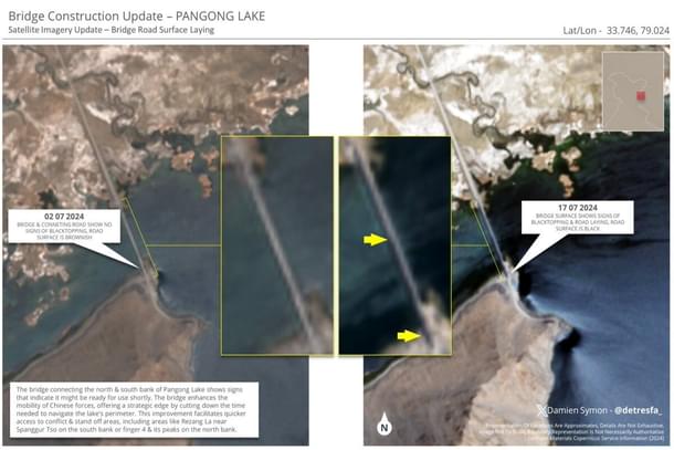
Satellite imagery reveals that China's under-construction bridge across Pangong Tso in Eastern Ladakh is almost complete.
High-resolution satellite imagery shared by X (formerly Twitter) user Damien Symon shows that the bridge is nearly ready, with the surface of the bridge recently blacktopped.
Although the exact date when the construction started is not known, according to experts, the first signs of erection of structures around the area started appearing in the last days of September and early October of 2021.
The bridge is coming up near the Khurnak Fort, at one of the narrowest points of the 134-km-long Pangong Lake.
China occupied the area around Khurnak Fort in June 1958.
The bridge will connect the northern bank of Pangong Tso Lake with the southern bank, allowing the Chinese to rapidly switch forces from one bank to the other, apart from the swift movement of supplies and material to forward areas.
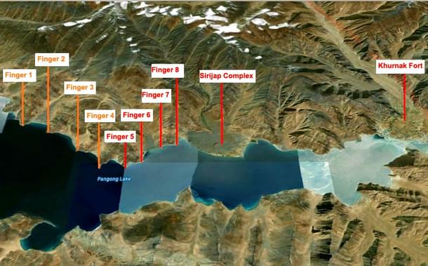
This bridge is very close to the Line of Actual Control (LAC) according to India's claim — just 25 kilometers from Sirijap, which lies just east of the Finger 8 area that India claims as its own.
The bridge construction started after the clash at Pangong Tso in May 2020, following which a larger clash happened in Galwan Valley in June 2020.
Since the Galwan clash, which claimed the lives of 20 brave Indian soldiers and an unknown number of Chinese soldiers, Indian and Chinese troops have been engaged in a protracted standoff that does not looks to end anytime soon.
Staff Writer at Swarajya. Writes on Indian Military and Defence.
Get Swarajya in your inbox.
Magazine