World
Pangong Tso Stand-Off Explained: The Change In Status Quo By China That India Wants Reversed
- Growing Chinese presence in the grey areas of the LAC will lead to change in the status quo, which India wants reversed.
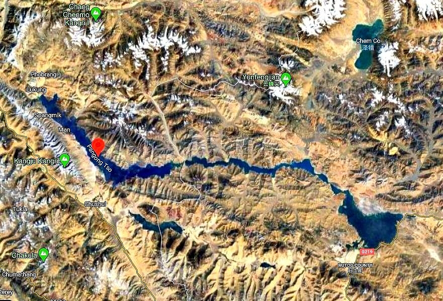
The 135 km-long Pangong lake lies 54 kilometres southeast of Leh. (Google Maps)
The India-China stand-off in Ladakh is now in its fourth week and the signs of it being serious are visible — a series of talks between the Indian and Chinese armies have failed to resolve the crisis. Both sides have amassed troops and equipment in the region, and Delhi and Washington have discussed the issue formally.
The Narendra Modi government, however, has decided not to give out any details of the situation on the ground. In the absence of details, two types of reports have emerged over the past 20 days — one based on sources and the other based on satellite imagery.
To make the lack of details worse, reports have been making contradictory claims. While source-based news reports say that the People’s Liberation Army (PLA) has entered Indian territory, those based on satellite imagery suggest that China is not in occupation of any territory that has been under Indian control.
The contradiction in reports has been further complicated by the fact that Defence Minister Rajnath Singh, in a series of interviews, has said, although not in the clearest terms, that there is indeed a crisis at the Line of Actual Control (LAC), China has brought troops in the region in ‘good numbers’ and India has done what it had to — to respond — hinting that there has been a change in status quo which India wants reversed.
This has led many to ask one particular question — if there is no Chinese intrusion into Indian controlled territory, as satellite imagery appears to show, what is the face-off between the Indian and Chinese armies about, and which ‘change’ in status quo does New Delhi wants reversed?
Before finding an answer to this question, one must note that India and China have differing perceptions of the LAC. While they agree on the alignment of the line in some areas, they don’t in others.
This, as Mihir Shah explains in this thread and a piece in Newslaundry, means that there exists grey regions between the settled areas of India and China. Both sides patrol the grey areas and most of the fistfights between Indian and Chinese troops take place in such regions.
If one of the sides blocks access to a grey area to the other side, it amounts to a change in the status quo on the ground — the blocking side gets exclusive control of the grey area in question while the other side can’t send in patrols.
In the Galwan Valley region, one of the places in eastern Ladakh where a stand-off was reported, the LAC is considered ‘settled’, which means China and India largely agree on the alignment of the LAC. Grey areas, most likely, don’t exist here. But that’s not the case in the Pangong Lake area, where there is a large grey area that both sides patrol.
The 135 km-long Pangong Lake, a portion of which is in Tibet, is the world's highest saltwater lake, and lies 54 kilometres southeast of Leh.
North of the Pangong Lake lies the Chang Chenmo range. Spurs which jut out from this range, running mostly perpendicular towards the northern bank of the Pangong Lake, are called ‘fingers’ by the Indian Army. These fingers are labelled 1 to 8 in a map of the lake’s northern bank below.
While India holds area upto the western side of Finger 4, which is also called Foxhole Point or Foxhole Ridge, and claims that the LAC runs through Finger 8, China claims that the LAC is close to Finger 2. India has been sending patrols upto Finger 8 for years while the Chinese patrol upto the eastern side Finger 4.
India’s Indo-Tibetan Border Police has a camp between Finger 2 and 3, marked in the map above in orange. It was set-up sometime around 2013-14. The Chinese have a base in the area east of Finger 8, marked in the above map in red.
As a result, a grey area, which both sides patrol (not without friction), exists between Finger 4 and 8. This region is at the centre of the current stand-off.
Latest high-resolution satellite images from Planet Labs, posed by an open-source intelligence (OSINT) analysts, @detresfa_, on Twitter, suggest that new Chinese camps have come up in the area just east of Finger 4.
New camps, most likely Indian, are visible on western side of Finger 4, which India controls. New developments close to the Indian ITBP camp between Finger 2 and 3 were also be seen in satellite images posted on 30 May.
Chinese camps appear to be spread across the entire area between Finger 4 and 6, and earth-moving equipment can be seen on the eastern part of the Finger 4.
New trails, starting close to the Chinese camps and leading towards the finger heights are also visible in the satellite image below.
These images confirm what has been suspected for the weeks now — growing Chinese presence in the grey area between Finger 4 and 8.
China did not have a post between Finger 4 and 8 before the stand-off. It had built a motorable road in the grey area in 1999 when India was busy evicting Pakistan from Kargil.
China is not in occupation of Indian controlled territory — it doesn’t need to occupy territory west of Finger 4 to change the situation on the ground.
With the Chinese present between Finger 4 and 6 in large numbers, Indian patrols, which earlier used to go as far as Finger 8, where the Indian claim line lies, will not be able to move beyond Finger 4. This, in effect, will give China the control of the entire region between Finger 4 and 8 and the adjoining heights.
This is the change in status quo that India wants reversed.
Support Swarajya's 50 Ground Reports Project & Sponsor A Story
Every general election Swarajya does a 50 ground reports project.
Aimed only at serious readers and those who appreciate the nuances of political undercurrents, the project provides a sense of India's electoral landscape. As you know, these reports are produced after considerable investment of travel, time and effort on the ground.
This time too we've kicked off the project in style and have covered over 30 constituencies already. If you're someone who appreciates such work and have enjoyed our coverage please consider sponsoring a ground report for just Rs 2999 to Rs 19,999 - it goes a long way in helping us produce more quality reportage.
You can also back this project by becoming a subscriber for as little as Rs 999 - so do click on this links and choose a plan that suits you and back us.
Click below to contribute.
Latest