Defence
China's Bridge Over Pangong Lake Nearly Complete, Will Speed Up Movement Of PLA Forces In Part Of Eastern Ladakh
Prakhar Gupta
Apr 12, 2022, 10:42 PM | Updated Apr 13, 2022, 01:55 PM IST
Save & read from anywhere!
Bookmark stories for easy access on any device or the Swarajya app.
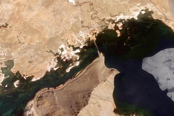

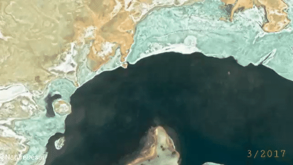
China's bridge over Pangong Lake, which it has been building in Indian territory under its occupation, is nearly complete, satellite images dated 11 April reveal.
High-resolution satellite imagery from Planet, shared by satellite imagery expert @NatureDesai, shows that the construction of the bridge, which began last year on the north bank of the lake, has now reached the southern bank.
The support structure required for the bridge's construction is visible in the image, which suggests that some parts of the bridge may still be incomplete and that it is at least a few months away from operationalisation.
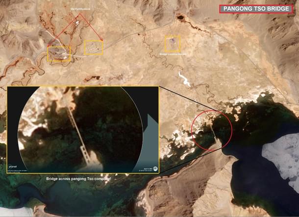
Where Is The Bridge Coming Up?
The bridge is coming up near the Khurnak Fort, at one of the narrowest points of the 134-km-long Pangong Lake.
China occupied the area around Khurnak Fort in June 1958. In the 1962 war, China expanded its control to the Sirijap Complex, further west of the Khurnak Fort. During the war, India had posts at Sirijap while the Chinese had a base at Khurnak. The 'Fingers' area, occupied by Chinese forces in May 2020, leading to the standoff that continues at some places in eastern Ladakh, is further west of the Sirijap Complex.
Large bases of the People's Liberation Army have existed at Khurnak and Sirijap since the 1960s. The map below shows the approximate location of Khurnak Fort, Sirijap Complex and the Fingers area.
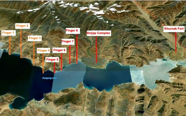
China is building the bridge very close to what New Delhi considers to be the border between India and Tibet. However, the place is around 25 km from Sirijap, where the Line of Actual Control (LAC) lies, according to India's claim. As visible in the map above, Sirijap lies just east of Finger 8.
North of Pangong Lake lies the Chang Chenmo range. Spurs that jut out from this range, running mostly perpendicular towards the northern bank of Pangong Lake, are called 'fingers' by the Indian Army. These fingers are labelled 1 to 8 in the map above.
India controls the area upto the western side of Finger 4, which is also called Foxhole Point or Foxhole Ridge, and claims that the LAC runs east of Finger 8. China claims that the LAC is close to Finger 2.
Before the standoff that began in May 2020, Indian patrols went upto Finger 8, and the Chinese patrolled the area upto the eastern side of Finger 4. During the standoff, the Chinese, who had a base just east of Finger 8, occupied the area between Finger 8 and the eastern side of Finger 4, blocking India from accessing the area.
As part of the disengagement deal reached in January-February 2021, the Chinese dismantled the posts they had built between Finger 8 and Finger 4 and moved back to their traditional base east of Finger 8. Indian troops, who had taken up new positions in response to China's occupation, went back to their Dhan Singh Thapa Post, just west of Finger 3. A no-patrol zone was set up between Finger 3 and Finger 8.
When Did The Construction Of The Bridge Start?
Satellite imagery experts say the first signs of the erection of the structure started appearing in the last days of September and early October of 2021.
In the satellite image of the Khurnak Plain (the alluvial fan of a stream known as Changlung Lungpa; also called Ote Plain) below, taken on 7 November 2021, the under-construction Chinese structure can be seen on the north bank of Pangong Lake.
The swift progress in construction and the harsh conditions at the site suggest that the Chinese could be using pre-fabricated structures, prepared at a different location, to erect the bridge.
The preparations for the construction of the bridge would have begun months before the first signs of it appeared in satellite imagery. This means that the preparations were underway when the Indian Army and the PLA were holding talks on resolving the standoff in eastern Ladakh.
How Will The Bridge Help China?
The PLA has a strong presence both north and south of Pangong Lake. On the north bank, it has large bases at Khurnak and Sirijap. Just south of the lake, it has bases on the bank of the Spanggur Lake.
The Kailash Range, on which the Indian Army occupied tactically important heights in August 2020, is located just west of Spanggur Lake. The area had seen intense fighting during the 1962 war, when India had airlifted tanks to this area.
The camps north and south of Pangong Lake are linked to large PLA bases in Rutok, a Tibetan town located at the eastern end of the lake. An extensive road network exists on both sides of the lake to link these bases to Rutok. However, forces from the north can't be moved to the south or vice versa at short notice because of the lack of a bridge over the lake.
If PLA's forces from the north of the lake have to move to areas south of the lake, they can use boats to cross the water body. This option has limits because a large force with heavy equipment can't be moved on boats. The other way for Chinese forces to reach the south bank from the north bank is to first go to Rutok, which is over 150 km away, and then turn west from Rutok towards the Spanggur Lake.
The map below shows the detour that the Chinese forces heading from the north of Pangong Lake to the areas on the south bank have to take.
With the construction of the bridge, the Chinese forces north and south of the bank can quickly cross the lake, which will cut down the distance between the Chinese forces located in the two sectors. The Chinese will not have to head to Rutok to reach the other side.
In the area south of Pangong Lake, China appears to be building a new road (see red dotted line in the map above) from Rutok to the north bank. This road will use the new bridge to cut down the distance between the bases in the north and Rutok.
The shorter travel time between north and south will help China mobilise forces at short notice in the event of a crisis, like the one seen when the units of the Indian Army and the Special Frontier Force occupied the heights of the Kailash Range overlooking Chinese positions around the Spanggur Lake.
Prakhar Gupta is a senior editor at Swarajya. He tweets @prakharkgupta.
Get Swarajya in your inbox.
Magazine