Defence
Depsang: Why India Regaining Patrolling Access In This Part Of Eastern Ladakh Matters
Prakhar Gupta
Oct 22, 2024, 06:08 PM | Updated Nov 13, 2024, 02:29 PM IST
Save & read from anywhere!
Bookmark stories for easy access on any device or the Swarajya app.
On Monday (21 October), India announced that it had reached an agreement with China under which it would regain access to patrolling points (PPs) that became inaccessible following the crisis along the Line of Actual Control (LAC) starting in April 2020.
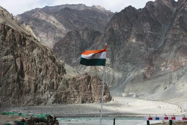
One of the many friction points that would see India regain access to patrolling points is the region called Depsang Plains, where India and China have been at loggerheads since before the stand-off that began in 2020.
Depsang is in north-eastern Ladakh, close to the Karakoram Pass. The highest landing strip in the world, Daulat Beig Old (DBO), is located only 30 km away.
The Darbuk-Shyok-DBO (DS-DBO) road, which was at the centre of discussion following the Galwan Valley clash in 2020, provides connectivity to this part of eastern Ladakh.

The Depsang Plains are important not only for access to the Karakoram Pass and the Indian post at Daulat Beg Oldi (DBO) but also because, amid mountainous terrain, they provide a flat surface that either country could use to launch a military offensive. This is similar to the Spanggur Gap in the Chushul sub-sector, where tanks were deployed during the current standoff as well as during the 1962 war.
With the new agreement in place, India would now have access to the patrolling points which had been inaccessible to Indian soldiers for years.
While the dispute in this region predates the situation that emerged on the LAC in April 2020, the region saw intensified Chinese presence, with the People's Liberation Army (PLA) building up its presence at a point called Bottleneck.
Indian patrols moving towards PPs 10, 11, 11A, 12 and 13, which lie close to the LAC, have to pass through the Bottleneck point.
The Bottleneck point is located around 7 kilometres away from an Indian base at Burtse, which is manned by the Indo-Tibetan Border Police (ITBP) and lies on the DS-DBO Road. The track going east from Burtse forks into two at the Bottleneck point. It is also called the Y-Junction by the Indian Army for this reason.
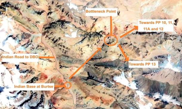
From the Bottleneck point or the Y-junction, one Indian patrol route heads north along Raki Nala towards Patrol Point (PP) 10, then turns east to PP-11 and 11-A, and finally south to PP-12. Another route leads southeast to PP-13, which lies south of these PPs and north of PP-14 in the Galwan Valley, where Indian and Chinese troops clashed earlier this month. With Chinese forces at Bottleneck, India couldn't access hundreds of square kilometres of territory it claims, as patrols can’t go to PPs 10, 11, 11A, 12 and 13.
Reports have confirmed that Indian troops will now have access to PPs 10 to 13 in the region, although how this is being ensured still remains unclear. Whether this involves the permanent withdrawal of Chinese presence near the Bottleneck point or not is a question that remains unanswered given the scant details released so far.
These patrolling points, which lie a few kilometres short of the LAC on the Indian side, are geographic markers set by the China Study Group, which was established by the Cabinet Committee on Political Affairs in the year 1976.
The PPs form the limit of patrolling and are routinely patrolled by Indian troops deployed in the area to assert a claim on the territory.
Over the last decade, the Chinese have made inroads into Depsang Plains and DBO. In one part of the sector, the PLA has built tracks and roads which stop just 4 kilometres short of an Indian post at what is called the Track Junction on the road leading towards the base and Advance Landing Ground at DBO. Concerned about the possibility of DBO and areas further east being cut off by the Chinese, India is working on a new road alignment to ensure access to this sector.
While India was already aware of the vulnerability of the DS-DBO road and had been constructing an alternate route to Daulat Beg Oldi, the stand-off in eastern Ladakh and the clashes in Galwan — which resulted in the first combat deaths on the LAC in decades — have induced urgency in the plan.
The new route to Daulat Beg Oldie is critical to reducing the risk of road connectivity to this sector of the LAC being interdicted by the Chinese.
As Rohit Vats explains in this video, the alternate route to Daulat Beg Oldie starts from Sasoma. Leh is already linked to Sasoma with a road that leads to the Siachen Glacier base camp. Sasoma lies on the same route, about 40 kilometers before the Siachen base camp.

From Sasser La, the road descends towards the Shyok River and Sasser Brangsa, located on the western bank. After crossing the Shyok River near Sasser Brangsa, the road goes towards Murgo. It joins the DS-DBO road at Murgo and then heads towards Daulat Beg Oldie, passing through the Depsang Plains.
On the Depsang Plains, the DS-DBO road runs very close to the Chinese claim line. The road passes through the Indian camp located at Burtse and runs 7 to 10 km from the LAC/1959 claim line as it heads towards DBO, making it highly vulnerable to Chinese interdiction on the Depsang Plains in the event of a crisis.
To bypass this stretch, the Border Roads Organisation is working on extending the road from Sasser Brangsa northwards towards the confluence of the Shyok River with Chip-Chap River, where it will turn east towards DBO.
This new route to Daulat Beg Oldie will ensure that the Indian Army does not lose access to this critical sector in the event of a Chinese interdiction of the DS-DBO road in the Galwan Valley, near the Burtse camp or at some other friction point in the Depsang Plains.
Also Read: From 1958 To 2022, The Story Of China's Occupation Of Khurnak And Its Bridge Over Pangong
Prakhar Gupta is a senior editor at Swarajya. He tweets @prakharkgupta.
Get Swarajya in your inbox.
Magazine


