Defence
Pokhran II: A First Hand Account Of Site Selection
Major General Mrinal Suman
Jul 05, 2020, 06:16 PM | Updated 06:16 PM IST
Save & read from anywhere!
Bookmark stories for easy access on any device or the Swarajya app.
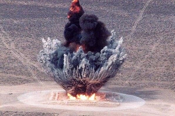

India's first nuclear test took place on 18 May, 1974, at Pokhran. The government termed it as a ‘peaceful nuclear explosion’ whereas it is more commonly referred to as Pokhran-I. After a hiatus of 7-8 years, a decision was taken in 1981-82 to proceed with another nuclear test, i.e. Pokhran-II.
Following the precedence of Pokhran-I, the task of sinking shaft for the test was assigned to the engineer regiment located at Jodhpur, the nearest major cantonment. 113 Engineer Regiment, raised in 1967, had already scripted an enviable record of indomitable spirit and valour. It had arrived at Jodhpur in late 1979. The late Lt Col KC Dhingra (later rose to the rank of Major General) was commanding the regiment. I was a company commander in the regiment.
Col Dhingra was called to New Delhi for urgent discussions in January 1981. On his return to Jodhpur, he asked me to accompany him for an operational reconnaissance to the border region. We set out in two jonga vehicles. He drove the first vehicle and I sat in the co-driver’s seat. The support staff was in the second vehicle. En route, he told me that the regiment had been tasked to sink a 12-feet diameter shaft to more than 500 feet depth.
Both of us well understood the purpose of the shaft, yet the word nuclear or atom or test was never uttered. In fact, such taxonomy was never used by anyone during the entire task.
In hindsight, we knew it was a difficult assignment but did not comprehend the enormity of the challenge. We were civil engineers and knew little of mining engineering. In fact, we had never visited a mine nor seen a shaft.
A word about shaft sinking will be in order here. To approach underground mineral seams, a vertical opening (shaft) is provided from the surface to the mining zone. These shafts are used to carry men, material and equipment to the mining zone; as also, to haul the extracted ore to the surface. All mining manuals term shaft sinking to be the most dangerous and hazardous task of all mining operations. It requires domain expertise and specialised equipment.
As regards our task, site selection was left to the regiment. With maps of the Pokhran ranges in our hands, we traversed the ranges a number of times over the next two days to get a feel of its expanse. We identified a nine square km area that was well away from the highways and the villages, thus satisfying our security and secrecy concerns.
After our return to Jodhpur, Col Dhingra apprised the authorities at New Delhi about the general area selected. Once the go-ahead was received, I was asked to proceed to the Pokhran ranges to select the site. Captains NPS Chauhan and DK Rajput accompanied me with a party of twenty jawans. We reached the ranges at sunset. Unable to reach the pre-selected area, we decided to camp for the night in a flat area along the cart track Khetolai-Loharki. A 180-pound tent was quickly pitched for the three officers while the jawans slept in the 3-tonne vehicles.
Before going to bed, we were discussing the next day’s course of action in the dim light of the lantern when Capt Rajput shouted ‘snakes’. We looked down and were frightened to see tens of vipers and scorpions crawling all over the place. Apparently, we had intruded into their habitat. It was a sight that could send shivers down the spine of the bravest of the brave. Throughout the night, we did not venture to get down from our camp-cots, pressure on the bladders notwithstanding.
The first thing that we did the next morning was to find an alternative camp site. However, little did we realise that vipers (called Russle’s Viper) were going to be an integral part of our lives during the entire duration of the task.
Viper is one of the most dangerous snakes. Vipers are responsible for more human fatalities than all the other snake species put together. As they move stealthily, the locals refer to them as Chor (thief) in hushed tones. While we had quite a few cases of snake bites, all victims were saved by timely administration of anti-snake venom by our regimental medical officer Capt VK Shukla.
For site selection, we traversed the whole nine square km area a number of times but to no avail. We knew that the site had to be in the inter-dunal flat area with least sand over-burden and sufficient space for camping. As Pokhran-I had suffered severe reverses due to underground water, our aim was to identify a location with minimum chances of encountering water. But, we had no knowledge or idea as to how to identify such a site.
We decided to meet the local inhabitants of Khetolai and Loharki villages to get benefit of their ground knowledge. We told them that the army wanted to establish a permanent camp in the ranges and was looking for a site where water could be struck. They were very helpful and showed us numerous sites where they had attempted wells without striking water. They advised us to avoid those areas; and look for beri (Indian Jujube tree) and termite mounds as their presence generally indicates underground water.
At the end of the second day, we were no wiser as regards the selection of site. However, with no reptiles for company, we spent the night in peace. Next morning, we visited Jaisalmer and Pokhran towns to consult experts of the Central Ground Water Board and Rajasthan Ground Water Department. With the help of hydro-geological maps, they explained that the Pokhran ranges were a part of the lower Jurassic Lathi Formation, underlain by intrusive rocks at the basement consisting of granite, medium to coarse grained sandstone, shale and conglomerate.
As the main water bearing formations occur under unconfined to confined conditions in weathered/fractured zones, they could indicate presence of major aquifers trapped in impervious granite strata at depths of 1200 feet with reasonable certainty but not the perched aquifers at lesser depths. As we had to go down to 500 feet, the information was of little use.
We decided to approach Central Arid Zone Research Institute (CAZRI) at Jodhpur as well. Most disappointingly, they also underlined the impossibility of predicting perched aquifers and underground streams. CAZRI helped us with geologic and topographic maps of the area. We studied them in detail but no tangible inferences could be drawn. The challenge of selecting an exact spot for digging was proving overwhelming. As pressure from New Delhi was building up, Col Dhingra asked us to revisit Pokhran ranges to expedite site selection.
With the inputs acquired from different agencies, another detailed reconnaissance was carried out and four sites (A, B, C and D) were tentatively shortlisted, with their inter-se distance varying between 900 to 1400 meters. All the sites were in hard crusted inter-dunal flats with sufficient space for erecting rigs and other infra-structure. Close proximity of sand dunes was considered essential for concealing disposal of dug earth, lest prying satellites notice our activities.
We contacted the local villagers once again to obtain their views regarding the possibility of striking water at the four shortlisted sites. The well-meaning village elders advised us to seek the help of local water-diviners.
Water-divining or dowsing is an ancient practice of using a divining rod to find sub-terrarium water. It is said that Moses searched for water in the Sinai desert using his divining rod around 1250 BC. Water dowsing is based on the belief that perturbations on the earth's magnetic field may coincide with the existence of groundwater. A dowser’s body serves as an electrical conductor and when it moves through the earth's magnetic field, small electric potentials are generated.
Some dowsers use forked sticks while others use two steel rods bent into L-shape. They are held in hands loosely so that even a slight hand motion (influenced by magnetic field perturbations) becomes sufficiently noticeable. However, as their approach is solely sensory, the dowsers can neither guarantee the presence of water (including depth and quantity) nor its absence. We found the idea interesting but brushed it aside as being non-scientific.
The next evening, without informing us, the local headman of Khetolai village brought a dowser from Pokhran town to our camp site and asked him to appraise the sites. It was a full moon night. The dowser took out a freshly plucked forked twig of local beri tree from his bag and washed it with water with a short incantation.
It was a surreal experience for all of us. Nonetheless, we were relieved to hear the dowser declare all the four sites unfit for water prospecting. Even though it was a gratuitous input without any scientific authentication, we certainly felt upbeat. It sounds incongruous that a dowser’s testimony also played a part in helping determine the site for a nuclear test! Indeed a weird proposition.
During Pokhran-I (January 1974), ingress of water had stalled the progress within three months of commencing digging. The incomplete shaft had to be abandoned and a dry abandoned well was prepared for the test. For our proposed test (Pokhran-II), a 500 feet deep shaft was essential. No abandoned well could meet that requirement as they rarely exceed 120 feet depth. Hence, the authorities decided to attempt digging at two sites simultaneously to cater for unforeseen contingencies. Thus we had to select two out of the four identified sites. We did much brain-storming but doubts continued to linger.
Although wary of compromising secrecy, Col Dhingra agreed to seek help of a local hydrogeology agency that specialised in water prospecting for wells. The agency was told the same story i.e. the army was looking for a camp site with a water source. The agency could carry out core drilling for geologic sampling up to 150 feet only. Once again, the core logging declared all the sites ‘unfit for sinking well’, meaning thereby that water was not available in exploitable quantity. Thus, it was a supportive report but not a clincher, as the depth probed was only 150 feet.
As a last resort, we obtained the services of a government agency to employ geophysical method of detecting underground aquifers. The method is based on the capacity of the soil or rock to conduct electricity and the measurement of its conductivity. A direct current is sent down into the earth at the selected spot and electrodes placed in different arrays record the measurements. Deductions are drawn about the depth, size and quality of water bodies. As the efficacy of the equipment employed precluded any substantive result beyond 200 feet depth, their results were also not conclusive.
A number of meetings were held by Col Dhingra to collate and analyse all the inputs received. Painstakingly, comparative site appraisals were carried out. Sites A and C emerged as the preferred sites. It must be admitted that hunch and the proverbial sixth sense also played a considerable role in the final selection. Thereafter, Col Dhingra and I proceeded to Pokhran for confirmatory ground reconnaissance. Maps had to be annotated to convey the grid references to New Delhi.
By the time we reached Site A, the sun was already going down. The centre point of the proposed shaft was duly fixed on ground. I requested Col Dhingra to do the honours of driving an iron picket as the marker. A soldier held the iron picket on the spot and Col Dhingra was given the hammer. He stepped forward while the rest of us formed a circle around him.
It was a momentous occasion. With the setting sun’s rays lighting up sand dunes in different hues of golden colour, it was an idyllic experience. The tranquillity of the desolate desert added peculiar solemnity to the surroundings. Col Dhingra faced the sun, closed his eyes for a minute and perhaps, sought heavenly blessings. Significance of the occasion had overwhelmed us all and we were standing as if in a trance, which was broken with the thud of the hammer blow.
As it was getting dark, we rushed to Site C which was 900 meters away. The same procedure was repeated except that Col Dhingra asked me to drive the picket. It was a gracious gesture. During our long drive back to Jodhpur, we hardly exchanged any notes. The die had been cast. Future of India’ nuclear ambitions depended on our site selection. The thought weighed heavily on us.
Once the go-ahead was received, digging started in all earnest. After clearing the sand over-burden, we encountered a conglomerate consisting of gravel, sandstone and siltstone. At 60 feet depth, we encountered water seepage. Going was tough but the spirits remained high. By the time we reached 90-100 feet depth, the rate/quantity of water ingress had made drilling impossible. The work came to a standstill.
But the indomitable spirit, never-say-die approach and ingenuity helped 113 Engineer Regiment overcome all odds. As the saying goes – “Histories are scripted by the audacious.”
Let the story of our struggle and success in taming water ingress be held in reserve for another day.
The author commanded his regiment in the Kargil-Siachen sector and was the Task Force Commander at Pokaran for sinking shafts for the nuclear tests. He is a prolific writer and is considered to be the foremost expert on myriad aspects of India’s defence industry, procurement regime and offsets.
The author commanded his regiment in the Kargil-Siachen sector and was the Task Force Commander at Pokharan for sinking shafts for the nuclear tests. He is a prolific writer and is considered to be the foremost expert on myriad aspects of India’s defence industry, procurement regime and offsets.
Get Swarajya in your inbox.
Magazine