Infrastructure
Explained: The Need For Balancing Development And Conservation With Rs 6,000 Crore Kaziranga Elevated Road Project
V Bhagya Subhashini
May 11, 2023, 01:01 PM | Updated 01:42 PM IST
Save & read from anywhere!
Bookmark stories for easy access on any device or the Swarajya app.
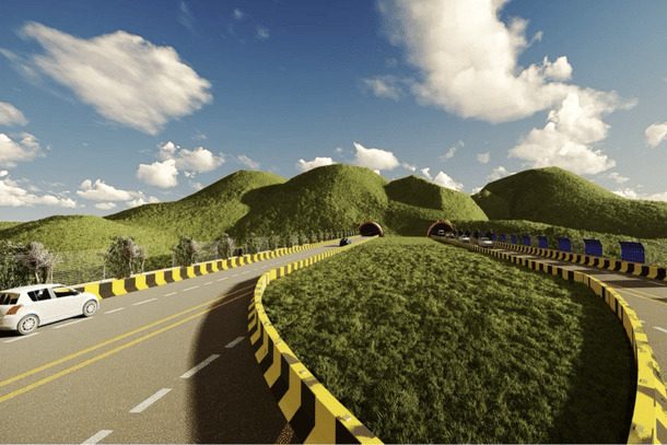
Union Minister for Road Transport and Highways Nitin Gadkari conducted a review of the progress of the Kaziranga Elevated Road Project on Wednesday (10 May).
Kaziranga National Park, situated in Assam, is a United Nations Educational, Scientific and Cultural Organization (UNESCO) World Heritage Site of India and is known for the great Indian one-horned rhinoceros.
The Kaziranga Elevated Road project entails the construction of approximately 34 kilometres of elevated roads at sites identified by the Wildlife Institute of India (WII), where animal crossings occur.
The elevated highway will run alongside the present NH 715.
Assam's Public Works Department (PWD) has requested permission from the Environment Ministry to build a greenfield four-lane elevated road for the execution of wildlife-friendly measures on the Kaziranga National Park segment of NH 715 (previously NH 37).
The expert appraisal committee (EAC) of the Union Environment Ministry has recommended that terms of reference (ToR) be granted to the Assam government's long-pending request to build a new four-lane elevated highway with animal crossings to replace NH 715.
The ToR grant is an important aspect of obtaining environmental clearance for large projects. Following the approval of the ToR, the project will undergo public consultations, culminating in final environmental clearance from the Centre.
Over 70 hectares of land will be required for the project, which will need the removal of over 3,000 trees. For local needs, EAC has sought bare minimum tree removal and an access-controlled structure.
Salient Features Of The Project
The four-lane project will run along an existing arterial highway (NH 715) and will be built at a cost of Rs 6,000 crore.
Additionally, it involves widening the intervening at-grade road to a four-lane highway, totalling approximately 50 kilometres in length, and building tunnels spanning approximately 3km kilometres. The alignment was determined in collaboration with the WII.
The elevated road is planned to be built over nine corridors used by the animals of the Kaziranga National Park (KNP) usually during high floods.
The nine identified corridors are Panbari, Haldhibari, Bagori, Harmati, Kanchanjuri, Hatidandi, Deosur, Chirang and Amguri.
This will have a vertical clearance of 9-10 metres for animals' passage underground, two tunnels, and nine animal corridors in the Nagaon and Golaghat districts.

Noise barriers and head light diffusers with vegetated panels and solar panels would be installed on the project.

The project will also feature cut and fill tunnels for animal overpass.

Need for Kaziranga Elevated Road Project — Roadkills, Habitat Fragmentation
NH 715 is a 61 km stretch, running along the southern boundary of Kaziranga National Park, between Bokakhat and Ghorakati ranges. It connects Assam and Imphal.
Kaziranga National Park provides a habitat for Bengal tigers, Asian elephants, and two-thirds of the world’s one-horned rhinoceroses, as well as a diverse array of smaller mammals, reptiles, amphibians, and birds.


Kaziranga National Park is bordered to the north by the Brahmaputra River, which floods the park every monsoon season (June–September).
As the rains begin, many animals are forced to cross the NH to access the higher-elevation hills in the Karbi-Anglong district to the south, becoming vulnerable to collisions with vehicles.

Previously, this was not a serious concern because the park's woodlands and grasslands formed a unified natural unit with few human habitations.
However, in recent years, NH 715, which runs parallel to the park's southern edge, has opened up the area to tea plantations and settlers, and as a result, the forest cover has decreased, resulting in habitat fragmentation.
The traffic on the 54 km stretch of highway also acts as a barrier to animals moving from the park to the Karbi Anglong hills during the monsoon.
This has affected the natural movement of animal communities between grasslands and woodlands in the landscape to avoid floods as well as to forage and other life processes.
According to WII research, 1,176 wild animals were killed along the 64-kilometre course of the highway in KNP between January and December 2019. The number of animals killed on the roads has increased over the years.

With this project, the wild animals crossing from Kaziranga to Karbi Anglong will be provided a safe passage to maintain the integrity and sustainability of Kaziranga National Park.
Balancing Conservation And Development — Boost To Tourism
Additionally, the project is also expected to boost tourism in the region, which is a significant contributor to the state's economy.
Viewing platforms on the elevated road, complete with vehicle parking and kiosks will be included to provide tourists with an opportunity for wildlife watching.


The project will ensure preservation of Kaziranga Landscape. It will present a good example of coexistence of conservation and development to be emulated in projects through natural areas.
V Bhagya Subhashini is a staff writer at Swarajya. She tracks infrastructure developments.
