Insta
With Two New Union Territories, Here Are The Latest Political Maps Of India Released By The Indian Government
Swarajya Staff
Nov 02, 2019, 08:00 PM | Updated 07:59 PM IST
Save & read from anywhere!
Bookmark stories for easy access on any device or the Swarajya app.


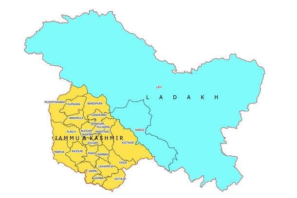
With the twin Union Territories (UTs) of Jammu & Kashmir and Ladakh coming into existence from 31 October (Thursday) through the Jammu and Kashmir Reorganization Act, 2019 the political map of the country has also undergone a change.
The new political maps of India and new UTs have been released by the government to mark the development.
Two political maps of the country have been released by the government, linked here, and here.
The new Union Territory of Ladakh consists of two districts of Kargil and Leh. The rest of the former State of Jammu and Kashmir is in the new Union Territory of Jammu and Kashmir.
In 1947, the former State of Jammu and Kashmir had the following 14 districts - Kathua, Jammu, Udhampur, Reasi, Anantnag, Baramulla, Poonch, Mirpur, Muzaffarabad, Leh and Ladakh, Gilgit, Gilgit Wazarat, Chilhas and Tribal Territory.
By 2019, the state government of former Jammu and Kashmir had reorganized the areas of these 14 districts into 28 districts. The names of the new districts are as follows - Kupwara, Bandipur, Ganderbal, Srinagar, Budgam, Pulwama, Shupian, Kulgam, Rajouri, Ramban, Doda, Kishtivar, Samba and Kargil.
Out of these, Kargil district was carved out from the area of Leh and Ladakh district. The Leh district of the new Union Territory of Ladakh has been defined in the Jammu and Kashmir Reorganization (Removal of Difficulties) Second Order, 2019.


