News Brief
Amid Iran Conflict, IDF Posts Controversial Map Misrepresenting Indian Borders; Issues Apology After Outrage
Arzoo Yadav
Jun 14, 2025, 01:13 PM | Updated 01:28 PM IST
Save & read from anywhere!
Bookmark stories for easy access on any device or the Swarajya app.
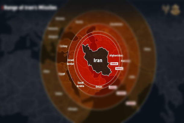
The Israeli Defence Forces (IDF) on Friday (13 June) released a map illustrating Iran's missile range, which inaccurately depicted Jammu and Kashmir as part of Pakistan and Northeast India as part of Nepal.
This map, released amid escalating military conflict between Israel and Iran, drew objections from Indian netizens, reported India Today.
Following the outrage over the map, the IDF issued an apology on Saturday (14 June).
The IDF posted the map, stating, "Iran is a global threat" and "Israel is not the end goal, it’s only the beginning."
They added, "We had no other choice but to act," referring to their military offensive.
The map also included India within the range of Iran's missiles.
Several users on X, formerly Twitter, raised objections over the map, saying it incorrectly depicted the entire map of India, with the Union Territory of Jammu & Kashmir and Ladakh shown as part of Pakistan and Northeaster states shown as part of Nepal.
Responding to an X post that flagged the inaccuracies, the IDF apologised on Saturday (14 June), clarifying, "This post is an illustration of the region. This map fails to precisely depict borders. We apologise for any offence caused by this image."
According to the map, apart from India, 15 other countries, including Russia, Ukraine, China, and Sudan, fall within the range of Iranian missiles.
On Friday (13 June), Israel launched massive airstrikes on Tehran as part of an operation aimed to dismantle Iran's nuclear enrichment programme.
In retaliation, Iran launched drones and missiles targeting several areas in Israel.
Hostilities escalated further on Saturday (14 June) with additional offensive attacks from both sides.
Get Swarajya in your inbox.
Magazine