Ideas
Floods Cannot Be Prevented In Assam, But Here’s How People’s Sufferings Can Be Mitigated
Jaideep Mazumdar
Jun 26, 2022, 09:05 PM | Updated 09:04 PM IST
Save & read from anywhere!
Bookmark stories for easy access on any device or the Swarajya app.


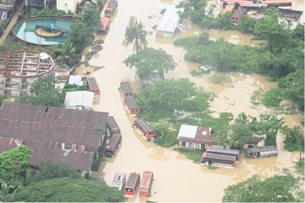
Assam is currently in the grip of devastating floods that have inundated vast swathes of the state, rendered lakhs of people homeless and taken a toll of 122 lives (as on Saturday, June 25). The state government, along with aid agencies and NGOs, is focused on providing relief to the displaced and flood-affected people.
But floods are an annual occurrence in the northeastern state. In fact, Assam is wracked by at least three cycles of floods between late April and September every year. And there’s nothing that any government or agency can do to prevent the floods, at least not to any significant extent.
That’s because most of Assam lies in the floodplains of the two major rivers that flow through the state--the Brahmaputra and the Barak. Of Assam’s total geographical area of 78,438 square kilometers, 70,634 square kilometers lie in the Brahmaputra basin while 6800 square kilometers lie in the Barak basin.
These two rivers bring in huge volumes of water, and silt, from the Himalayas and from the hills of Manipur and Mizoram respectively. Most of the tributaries of these two rivers are rain-fed and, thus, lead to the swelling of the rivers during the monsoons.
The silt that the rivers and their tributaries bring down from the mountains and hills is deposited in the flood plains of Assam and result in a steady decrease in the carrying capacity of these two rivers. As a result, the excess water in the rivers during the monsoons spill their banks and cause devastating floods every year.
There are only two ways that the waters from the swollen rivers can be prevented from spilling their banks. One is to enhance the carrying capacity of not only the two major rivers, but also their tributaries that flow through Assam. That can be done through dredging, but it is too costly and unsustainable an exercise.
The second is to build strong embankments along the banks of the rivers so that the excess monsoon-fed waters do not spill over and cause floods. But that, too, is a very expensive proposition and can lead to greater devastation if embankments get breached.
Floodplains, as the name suggests, are low-lying areas along rivers that are prone to flooding. But these floodplains are also very fertile because of the alluvial deposits by the rivers during floods.
In the past, Assam’s floodplains were sparsely populated. But the British, realising that the fertile floodplains were lying fallow and in order to enhance food production, brought in Muslim peasants from the then East Bengal (present-day Bangladesh) and settled them in the floodplains.
The hardworking Muslim peasants started cultivating the floodplains of Assam. They were joined by lakhs of fellow landless Muslim peasants from East Bengal. These migrants settled down in the floodplains, which have now turned into thickly-populated areas.
That’s why the floods affect so many people in Assam today. In the past, the floods would cause barely any misery to people of the state since the floodplains were very sparsely populated. But with the number of people residing in the floodplains, which also host many towns today, having gone up exponentially over the past many decades, the number of people affected by Assam’s annual floods has also gone up by leaps and bounds.
The way out
Since there is no way that floods can be prevented, the only option before the state government is to mitigate the sufferings of the people living in the floodplains of the state.
The first thing that needs to be done is to build permanent flood shelters in all villages and towns that get inundated every year. These concrete flood shelters, built on stilts, should be stocked with adequate foodstuff and other materials before every monsoon so that people taking shelter in them during the floods have adequate food, fuel, medicines etc to sustain themselves for a few weeks. They should also have generator sets and other facilities that can help the flood-affected and displaced people.
These flood shelters, or a cluster of them in one area, should ideally have disaster relief teams attached to them. These teams should be stationed in the flood shelters at the start of the monsoon season so that they can quickly rescue marooned people or evacuate people from the low lying areas before inundation.
These flood shelters can, for the rest of the year, be used as community halls for various public outreach activities and also house gram panchayat offices, health centres or other public facilities.
The state government would also be well-advised to carry out extensive topographical mapping of the floodplains. This will lead to low-lying areas being well marked on maps, thus aiding prompt evacuation of people living in the low-lying and flood-prone areas even before flood waters inundate those areas.
Such mapping will also enable the state authorities to station critical facilities like electric transformers and substations on higher ground so that they don’t get flooded. Various other facilities like schools, healthcare centres, pumping stations and government offices should be located on higher grounds identified by the mapping exercise.
Local topographical maps will also help authorities plan for floods well in advance. The state government should frame standard operating procedures (SOPs) that will kick into effect as soon as the met office sounds rain alerts in the catchment areas of the rivers.
In the longer run, the state government can encourage people residing in the lowest-lying and most flood prone areas to shift to higher ground. And researchers and experts in institutes, including the Indian Institute of Technology (IIT) at Guwahati, should be commissioned to come up with materials and designs of houses and structures that can withstand the annual inundation.
Close monitoring of the water levels of the rivers will enable local authorities to identify the areas which can get flooded and thus evacuate residents of those areas. In case of widespread floods--as in Assam at present--the flood shelters would not be able to accommodate the lakhs of displaced people. In that case, the maps will help authorities identify higher ground to build temporary relief camps.
The topographical maps will also help the authorities chart out effective routes to provide quick relief to flood-affected areas and also to evacuate people from those areas.
Along with all this, traditional flood control measures like strengthening and fortifying existing embankments and building new ones in stretches identified by experts, and dredging critical sections of the rivers, should also be carried out.
All this will mitigate, to a large extent, the sufferings of the people of Assam due to the annual floods. People of Assam have to live with floods, and climate change will trigger more intense floods in the coming years and decades. The solution lies in minimising, or even completely eliminating, the damage to human habitats and lives that the floods cause.
Jaideep Mazumdar is an associate editor at Swarajya.


