Defence
China's Bridge On Pangong Lake In Ladakh: Five Things You Should Know About It
Ujjwal Shrotryia
Jul 30, 2024, 05:10 PM | Updated 05:10 PM IST
Save & read from anywhere!
Bookmark stories for easy access on any device or the Swarajya app.
China has completed the construction of the bridge across Pangong Tso Lake in Eastern Ladakh.
Just a week ago (on 22 July), Swarajya reported that the construction of the bridge was almost complete using high-resolution satellite imagery posted on X (formerly Twitter) by a user named Damien Symon. The imagery suggested that the surface of the bridge had recently been blacktopped.
Light vehicles can also be seen plying on the completed bridge. Although the exact date when the construction started is not known, judging from the satellite imagery captured in the early stages of the bridge, it is estimated that it began construction sometime in October or September 2021.
Here are five things that you should know about the 400-metre-long bridge:
(1) Built on the land under occupation since 1958
The bridge is coming up near Khurnak Fort, one of the narrowest points of the 134-kilometre-long Pangong Lake.
Khurnak Fort and the area around it were occupied by the Chinese in 1958, just four years before the war. Until 1962, India controlled the Srijap Complex, which is just 25 kilometres away from Khurnak Fort. However, during the war, the Chinese captured the Srijap Complex as well.
The Line of Actual Control (LAC) according to India's perception passes through Srijap, which lies east of Finger 8.
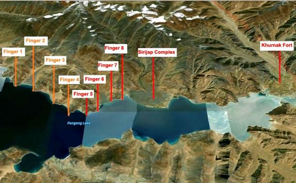
North of the Pangong Lake lies the Chang Chenmo range. Spurs that jut out from this range, running mostly perpendicular to the northern bank of the Pangong Lake, are called 'fingers' by the Indian Army. These fingers are labelled 1 to 8 in the map above.
India controls the area up to the western side of Finger 4, which is also called Foxhole Point or Foxhole Ridge, and claims that the LAC runs east of Finger 8. China claims that the LAC is close to Finger 2.
(2) Allows easy movement of troops from the northern bank of Pangong Tso to the southern bank
This bridge will ease the movement of Chinese troops and help them mobilise troops in the event of a crisis at very short notice.
.jpg?w=610&q=75&compress=true&format=auto)
Both the northern and southern banks of Pangong Tso have a significant presence of Chinese troops. However, their main headquarters is in the town of Rutok, which is 150 kilometres away.
Although the Chinese could transfer some troops across Pangong Lake using boats, this is not suitable for large-scale movement.
Therefore, the Chinese have to go across the lake to Rutok and then come back towards the other bank, which takes significant time. This bridge, along with a new road under construction from Rutok, will cut short this time and give them a tactical military advantage in the area.
(3) The bridge is now functional with light vehicles seen moving across
The bridge is now functional, with the road blacktopped just last week. According to satellite imagery, light vehicles were observed moving across the bridge.
This will become a big headache for the Indian commanders in the area since, in case of an eventuality on either bank of Pangong Tso, the Chinese can bring in reinforcements from the opposite bank really fast, while the Indian forces have to wait for reinforcements from other sectors.
Just like the Chinese, now Indian troops have to go across one bank and come to the other bank. This delays the reaction time of the Indian forces, which can be easily exploited by the Chinese.
(4) It is just 25 kilometres away from India's perception of the LAC
India's perception of the LAC extends from the Srijap Complex, which is just 25 kilometres away from the Khurnak Fort where the bridge has come up.
As already stated above, Srijap lies just east of Finger 8, which China claims as its own. In fact, it claims that the LAC is close to Finger 2.
Before the standoff that began in May 2020, Indian patrols went up to Finger 8, and the Chinese patrolled the area up to the eastern side of Finger 4. During the standoff, the Chinese, who had a base just east of Finger 8, occupied the area between Finger 8 and the eastern side of Finger 4, blocking India from accessing the area.
As part of the disengagement deal reached in January-February 2021, the Chinese dismantled the posts they had built between Finger 8 and Finger 4 and moved back to their traditional base east of Finger 8.
Indian troops, who had taken up new positions in response to China's occupation, went back to their Dhan Singh Thapa Post, just west of Finger 3. A no-patrol zone was set up between Finger 3 and Finger 8.
(5) Juicy target for the Indian Armed Forces
Although this bridge complicates operations for the Indian Armed Forces, all is not lost.
The bridge will be a juicy target for the Indian Air Force's guided missiles like the French-supplied Scalp-EGs missiles, Israeli Crystal Maze-2 (ROCKS), and Rampage air-launched ballistic missiles (ALBMs), apart from the Indian Army's BrahMos supersonic land-attack missiles.
These missiles can make this bridge unusable just like the Antonivsky Bridge in Ukraine across the Dnipro river connecting the city of Kherson to eastern Ukraine. Ukrainian High Mobility Artillery Rocket System (HIMARS) strikes riddled the bridge with holes, shaking its foundation and making it unusable for transferring heavy equipment.

Ultimately, the Russians were forced to use barges to move men and material from one bank to the other.
Indian forces can do the same with this bridge and force the Chinese to use boats complicating their logistics.
Staff Writer at Swarajya. Writes on Indian Military and Defence.
Get Swarajya in your inbox.
Magazine


