Insta
Super Cyclone Amphan Expected To Weaken Before Hitting West Bengal On Wednesday
Swarajya Staff
May 19, 2020, 01:06 PM | Updated 01:05 PM IST
Save & read from anywhere!
Bookmark stories for easy access on any device or the Swarajya app.


The Indian Meteorological Department (IMD) on Tuesday morning (19 May) said the super cyclone Amphan is going to slow down into an extremely severe cyclonic storm in the next couple of hours before hitting West Bengal on Wednesday, NDTV reported.
According to the department, the cyclonic storm is about to arrive at Digha in Bengal and an island in neighbouring Bangladesh near Sundarbans by Wednesday evening.
The department’s in-charge for cyclones Sunita Devi had earlier said that the weather conditions arising due to Amphan would cause heavy rainfall in coastal areas of West Bengal and Odisha on Tuesday.
The cyclone had yesterday entered the “super cyclone” category with wind speed above 200 km per hour. However, the speed is likely to come down to 180 km/ph by the time it strikes Bengal coast.
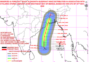
Last night, as per the IMD the super cyclone was over west-central Bay of Bengal about 600 km nearly south of Paradip (Odisha), 750 km south-southwest of Digha of West Bengal.
The Super Cyclonic AMPHAN at 2330 hrs IST of 18 th May, 2020 near latitude 14.9°N and longitude 86.5°E over Westcentral Bay of Bengal about 600 km nearly south of Paradip (Odisha), 750 km south-southwest of Digha (West Bengal) pic.twitter.com/cNSdwLEkq0
— India Met. Dept. (@Indiametdept) May 18, 2020
The IMD has issued an orange alert for coastal West Bengal and Odisha, where it said widespread damage is expected.
To review the situation, Prime Minister Narendra Modi also held a meeting with senior officials and took note of preparedness of authorities.
Currently, 32 National Disaster Response Force (NDRF) teams are deployed in the tow effected states, while 21 teams are on standby.


